M98 |
941 m. |
3087 ft.
Translation: Red hill
Pronuncation: caarn jerrack
3 June 2014 started out as a rainy day with drizzle and showers taking turns in raising the enthusiasm for hillwalking in remote hill country. But the Metoffice predicted a shift in the pattern and forecast nice weather with sunshine for the second half of the day. Accordingly the late morning saw Frank and me standing on the platform for the southbound trains at Tulloch Station.
The station is a nice building and it features a large roof which very conveniently protected us from the rain. In due course the train arrived; we boarded it, took our seats and bought our return tickets. The short trip from Tulloch to Corrour takes about twenty minutes. Loch Treig and the Eassins on the right-hand side, the very steep slopes of Stob Coire Sgriodain on the left of the track. Very scenic indeed. Then the train had finally climbed to the more open and level terrain of Rannoch Moor where Corrour Station came into view. There we disembarked, took a look around and then followed the Land Rover track towards Loch Ossian. We were accompanied by a dog, two horse riders and a cyclist who came from the Hotel at/in Corrour Station. There was even some car traffic on the track: Two Toyotas and a delivery van. Ahead we could see vehicles moving since some hydro works were under way.
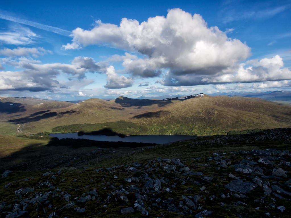
Just before came to the shore of Loch Ossian we turned right and picked up the path skirting the northern slopes of Meall na Lice and leading towards Peter’s Rock. The boulder carries a memorial plaque for one of the wardens of the Loch Ossian Youth Hostel who died there one lonely winter. From the Rock we climbed uniform slopes of grass and heather until we reached the broad north-east ridge of Carn Dearg. As height is gained the view opened up thanks partly to the Metoffice having been right. There was a delightful mix of sunshine and clouds. after maybe another thirty minutes we reached the summit cairn of Carn Dearg, covered in clouds, however. A short summit break, some refreshments, no views and on we went.
The path to the shallow col between Carn Dearg and Sgorr Gaibhre sometimes becomes indistinct but since the terrain is very easy that does not matter at all. The col itself was not half as squishy as the books had made us fear it would be. Soon we were on the climb up to the more conically shaped Munro of Sgorr Gaibhre. During the climb we met one rather uncommunicative walker who passed us by without a word. Strange. At the summit of Munro No.2 only a very short break was held since we were potentially competing against the clock: Trains don’t wait and we had to be back at Corrour for the last train.
From Sgorr Gaibhre’s summit we descended the rocky and sandy north east ridge towards Beallach nan Sgorr and then contoured around Meall Nathrach Mor the nose of which we bypassed on the left. Then we walked down nice grass slopes towards the forest edge visible in front of us. We picked up the land rover track beside the Allt a’Choire Chreagaich and entered the forest. The track took us towards the west end of Loch Ossian which we reached after a few minutes.
Again we were greeted by traffic from the hydro construction sites and the odd John Deere tractor. Oh well, these people make their living there so it’s ok of sorts. We crossed the outflow of Loch Ossian, walked by Corrour Shooting Lodge, with its remarkably different architectural style and finally made it on the Land Rover track on the northern shore of Loch Ossian. Then it was another two kilometres until we reached the path which branches off the track and leads up into the forest beside the left bank of the enchanting Allt Loch na Lap.
Once we left the trees behind the western slopes of Beinn na Lap came into view. We struck a direct line across the grass and moor towards the west ridge. There were some rock bands which could be navigated through on heather and grass. On and on we climbed until the steep final section before the summit of Beinn Na Lap was reached which we sort of scrambled up “a la diretissima”. Then at the summit we took a well-deserved break realising full well that we had more than enough time to enjoy the views and the sunshine since there were more than 100 minutes left before the train would leave Corrour Station. After some bites from our sandwiches, some handfuls of dried fruits and some water had been eaten/drunk we set out to complete the last leg of the hike.
The return to Corrour via Beinn na Lap’s east ridge was easy. The path follows the ridge at first and then drops due south down the side of the ridge towards the flatter terrain to the west of Loch Ossian. We arrived at the station with 40 minutes to spare. Unfortunately, the Hotel Bar is not open to the public on Tuesdays so no cold Coca Cola for us. A pity, but the views of the surrounding hills changing colours in the fading sunlight and the stars slowly appearing more than compensated for missing out on a cold drink in a warm bar. Then the train arrived and took us back to Tulloch and our car waiting for us in the dark.
An absolutely perfect day with very good tour planning done beforehand, great weather, lovely scenery and a marvellous approach by train into a really remote part of the country. The most enchanting tour of the May 2014 holiday in Scotland. Loch Ossian (and its Munros) is a place we definitely want to come back to!
Description These two mountains are the north-eastern half of the long ridge in the heart of the central highlands extending from Loch Ossian to Loch Pattack. They form a continuation of Beinn Eibhinn and Aonach Beag towards Loch Pattack . The summit of Geal-Charn is a large flat plateau with big corries to its north and north-east. Between these corries a narrow ridge extends north-east to Carn Dearg, and another ridge goes east to the sharp-pointed peak of Sgor Iutharn. These are remote mountains, and any approach to them involves a long walk or possibly the use of a bicycle along the tracks that lead into the hinterland from Dalwhinnie, Glen Spean or up the River Pattack.The most usual approaches are from the north, one starting at Dalwhinnie and going by Benalder Lodge to Loch Pattack and the other going from the east end of Loch Laggan up the River Pattack to Loch Pattack. From there continue along the Allt a' Chaoil-reidhe past Culra bothy and 3 kilometres beyond there climb west up the narrow ridge of Sgor Iutharn to reach the eastern edge of the Geal-Charn plateau. Go west across the plateau to the summit. Return north-east and descend the narrow ridge leading to Carn Dearg. From the summit of that hill descend east to Culra.The northern approach from Glen Spean probably involves more effort, going from the south-west end of Loch Laggan to Lubvan, possibly by bicycle, and then walking up the Allt Cam to the Dubh Lochan before climbing the northern slopes of Geal-Charn.