M194 |
961 m. |
3153 ft.
Translation: Hill of the speckled cliff
Pronuncation: byn kleebreck
This was a novelty: Climbing two Munros in one day but using a car to travel from the first to the second hill. We climbed Ben Hope from 10 a.m. to 2 p.m. and Ben Klibreck from 3 p.m. to 8 p.m. Frank and I parked the car in a layby on the A836 a kilometre north of Vagastie. From there we crossed the River Vagastie by a footbridge and followed the sometimes dry but mostly squishy path through high grass to Loch Bad an Loch. The surroundings of the Loch were very wet. From the flat land by the Loch we climbed to 150 metres to reach the south end of Loch nan Uan which nestles between Meall nan Uan and A’Chioch. Once at Loch an Uan we checked out the way ahead but could not make out any path from the loch leading up to A’Chioch. So we finally decided to climb the steep (!) grassy and heathery western slope of A’Chioch to reach the ridge at point 688m. This was a real slog! But we made it and stood on the defined ridge which we followed in a northerly direction. The wind had picked up quite considerably and was coming from a west-north-westerly direction. We were glad to walk in the lee of the crest of A’Chioch’s ridge! Soon we got to the flat area dotted with outcrops of rock, where the path veers east and the final 200m climb to the summit of Ben Klibreck begins.
The strong wind virtually blew us up the hill, bombarding Frank and me with a mixture of rain, sleet and snow. We stumbled on pushed and tossed around by the force of the wind. Then, after a seemingly endless climb the small summit plateau view its trig point and stone shelter came into view. The wind was so strong that we feared it might take us with it down the eastern slopes of Ben Klibreck. In fact it was quite tricky even to get into the circular stone shelter by the trig point since the entrance is on the east side directly where the steep eastern slope of Meall nan Con drops off. Finally we made it an enjoyed the relative calm in the shelter, drank some tea and munched some cookies. If getting into the shelter had been difficult getting out of it again was also not easy at all. Once we stuck our heads over the rim of the shelter we were knocked back.
Finally, using a moment of not quite so ferocious wind we climbed out of the shelter and headed due west down the 200m of Ben Klibreck’s summit slope. The wind immediately tore back my cagoule and almost unzipped my rain jacket. Stumbling, fighting to overcome the force of the wind on the steep slope we slowly fought our way back to the col between Meall nan Con and A’Chioch. For moments it felt like gravity had been switched off or reversed since walking down this steep summit slope of Meall nan Con we sometimes had to fight really hard to make progress downhill! Crazy! Once we reached the lee of the A’Chioch summit things we OK again. We followed the level path which skirts the western slopes of Carn an Fheidh and then walked down more easy angled grassy and heathery slopes aiming for Loch Bad an Loch. Even the sun shone for half an hour! At the Loch we picked up the path leading back to the A 836. Where our car was patiently waiting.
Drenched, exhausted and battered we finally crossed the River Vagastie by the footbridge, got to the car, peeled off layers of wet or damp clothing and set out on the way back to Letters. This was a demanding day on the two most northerly Munros, Ben Hope and Ben Klibreck. It is a real pity that there were hardly any views of the beautiful wide open spaces of the North!
<br> <br>
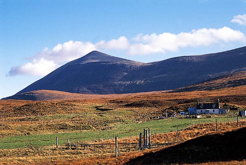
Description Ben Klibreck is an isolated mountain of broad ridges and grassy corries in the heart of Sutherland. Its west and north-west sides are quite steep and form a long escarpment overlooking Strath Vagastie, with a steep prow of broken crags below the summit of the hill, Meall nan Con. The south-east side of Ben Klibreck drops in long grassy slopes to Loch Choire.Despite its isolation in the flat moors of Sutherland, Ben Klibreck is only 4 kilometres from the nearest public road, the A836 in Strath Vagastie, and it is from there that the ascent is usually made. Leave the road at a point due west of Meall nan Con and cross the moorland eastwards, passing Loch na Glas-choille and Loch nan Uan to the foot of the steep western escarpment of the hill. Climb this to reach the broad spine of the hill about 1 kilometre south-west of the summit and finish along the ridge and up a boulder slope to the cairn. If the River Vagastie is in spate, it will be preferable to start further south at the bridge over the river near the outflow of Loch Bad an Loch.