Mullach Clach a’Bhlair

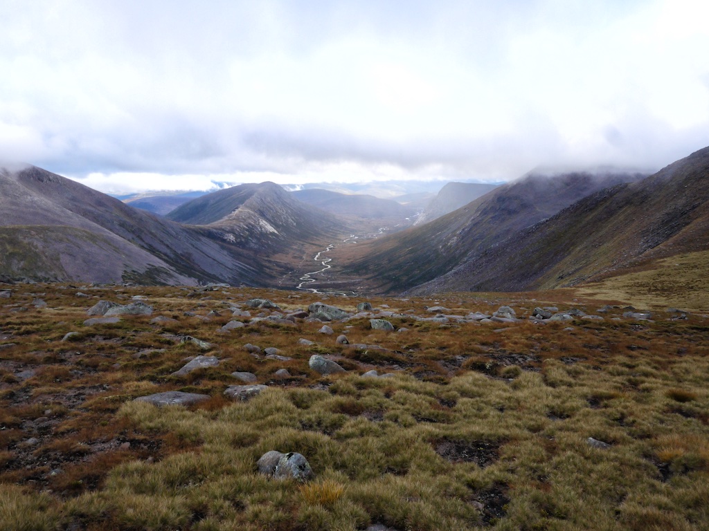
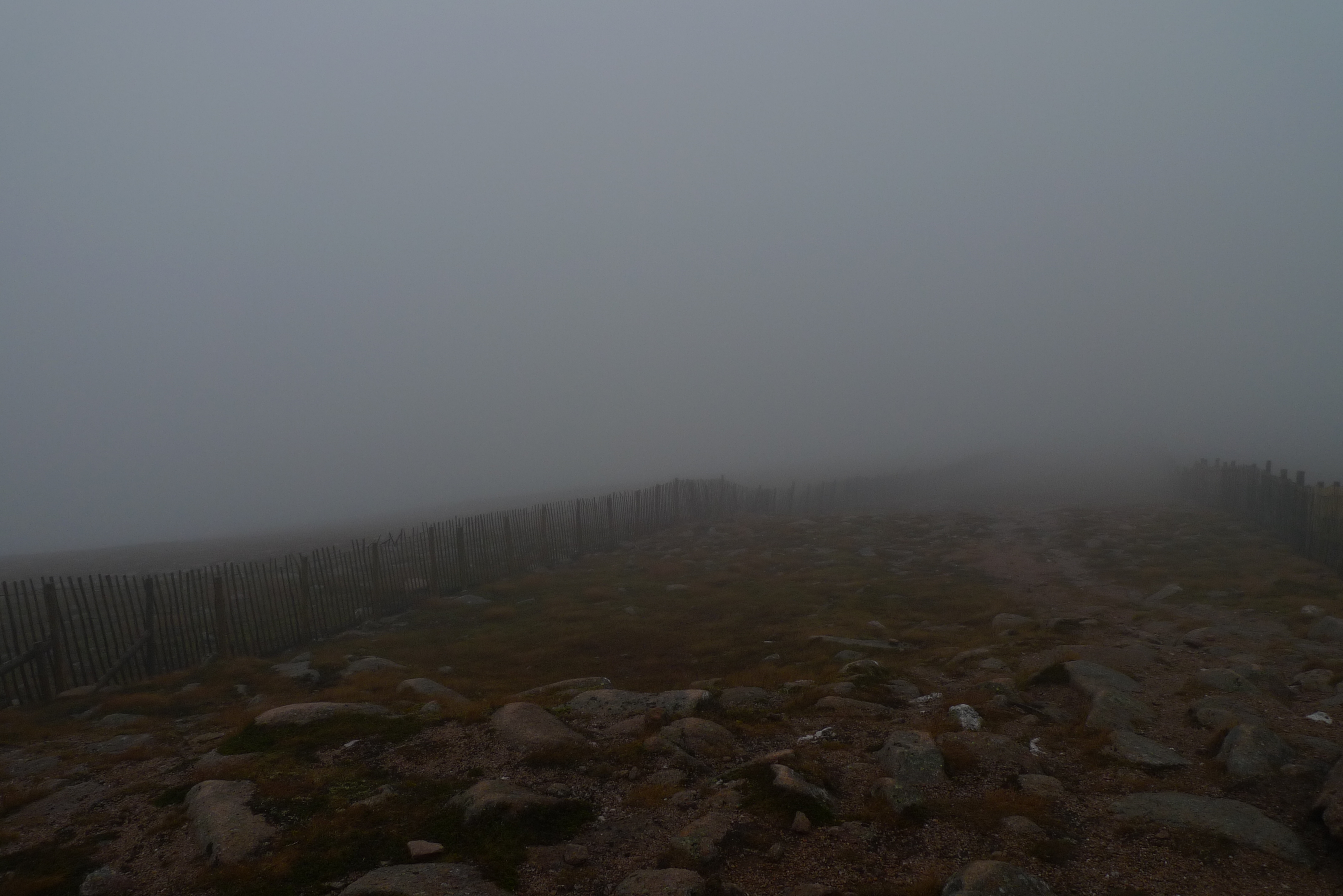
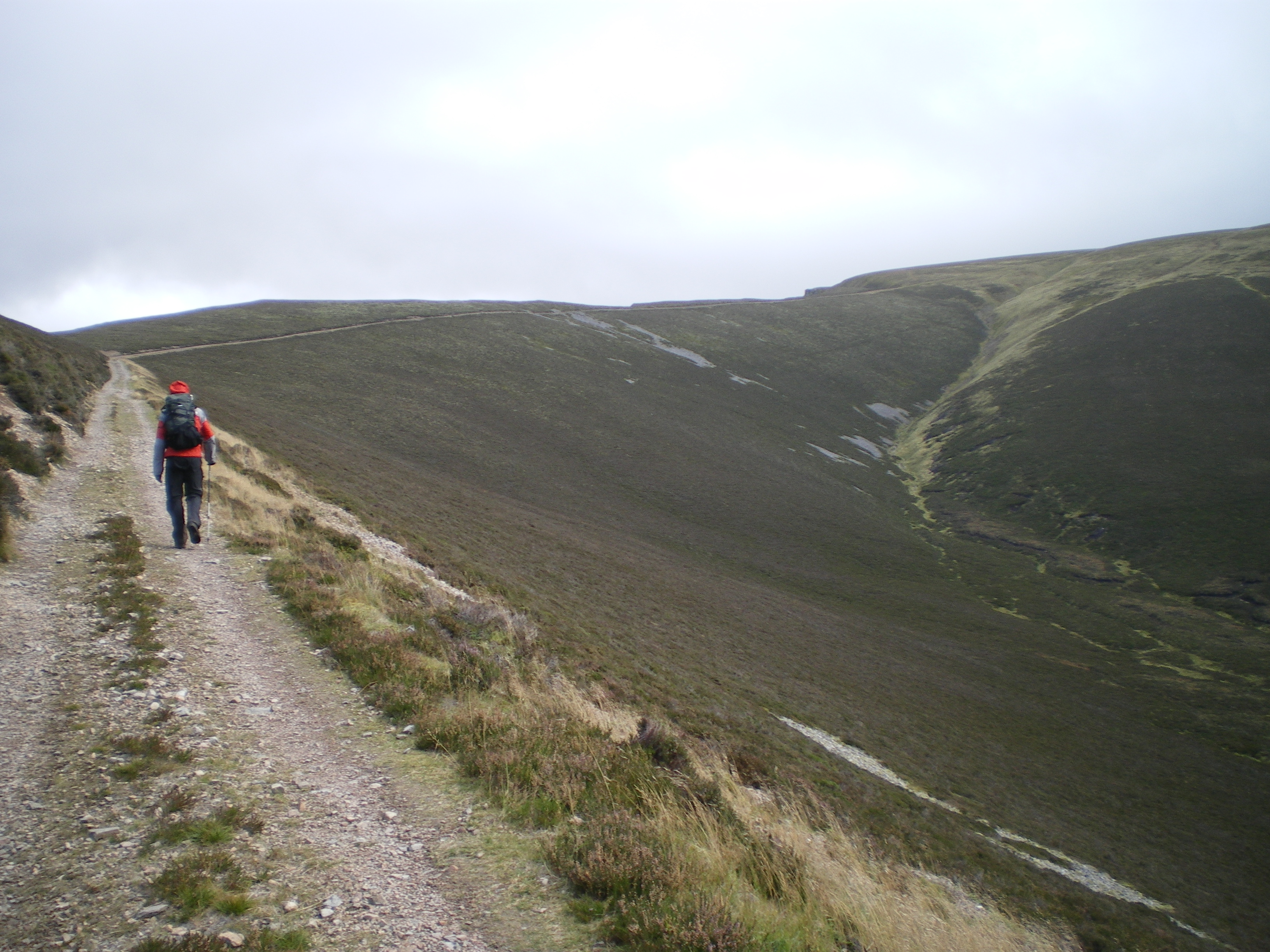
The day after Braeriach – half of the party called it a recreation day. Joachim, Cord and i headed for the Mullach. The revisit to Glen Feshie was really nice and the walk along the River Feshie was lovely. Unfortunately this was all the fun of the day since the hills were covered in clouds again. The track which brought us almost entirely to the summit is a broad piece of track. Long, straight and without any sense of humor. At least it was easy going except for the strong winds which greeted us when we reached the plateau. Ironically there we almost missed the cairn which shows the way to the summit. This summit was not only due to the zero views hardly recognizable as a summit. We touched the cairn and left. The way back was the same as the way to the summit. We were happy to reach the banks of River Feshie again for the sights and the going as well. This was the last walk of the 2011.2 munrobagging session. I had hoped for better views and weather. You can’t always get what you want.

2020-01-22T08:43:47+01:00October 3rd, 2011|2011, 2019 - 2010, The Cairngorms|

Sgor an Lochain Uaine

2011 This was supposed to be the “Kaisertour” of our extended Scotland 2011 weekend. It was kaiser but unfortunately the weather and clouds were not too kind to us. Since i had planned to go to Cairn Toul at least if not The Devil’s Point we started very early from the lower parking place. The mood was fine, the morning mist looked beautiful and the going was easy till we reached the Chalamain Gap. This is an impressive piece of rock gap which we mastered with some effort. Soon after the gap we lost height to cross Alt Druidh to start the ascent to the ridge.

Unfortunately we were too soon engulfed in mist and this should not change for the rest of the day. Bugger. When we reached the ridge we had very little view and we used the southern edge for orientation and walking. So we reached the summit of Braeriach after 4,5h which we celebrated with an well earned rest. The conditions were not too inviting so the break was not the longest one and we started over again. Thomas and Markus called it a day and returned. I gave them my Landranger copy (to be regretted later). The rest of the party made quite a navigational effort to continue near the ridge and try to avoid to get lost in the western Cairngorms. We succeeded in reaching the summit of Sgòr an Lochain Uaine. After a short consideration i decided to give Cairn Toul a try while Cord, Joachim and Stefan returned. They used our other map while i trusted in my iPhone and the Anquet software installed (to be regretted later).

So i did a speed as/descent of Cairn Toul. Since i did not want to reascent The Angel’s Peak i tried to walk around but due to zero views and the fact that my iPhone died in the rain i was without any mapping support. I did my best not to walk too low and too much to the south but i did not succeed. … [Read More]

2017-09-19T14:16:15+02:00October 2nd, 2011|2011, 2019 - 2010, The Cairngorms|

Cairn Gorm

2011 He we were again. The “Mechernich Group” and Cord on an extended weekend to enjoy and see the marvellous hills of scotland. We wanted to start with a moderate hill to get the old bones used to it. Bugger, we didn’t see anythin – but we had coffee!

From our lovely Treehouse in Boat of Garten it only took a short drive to the high level parking space an the base station of the Cairngorms ski area. I’ll never get used to those walks with these kind of infrastructure. It was very dizzy and we couldn’t see very much and this shouldn’t improve very much over the day … well we continued over skislopes and saw occasionally the skiing infrastructure.

Soon the infamous Ptarmigan came in sight but we headed directly to the marked path to the summit. Quite strangely this path is marked by post signs and one ought not leave it. After a short walk we arrived at the summit where we saw nothing, absolutely nothing. So we returned at once down to the Ptarmigan where we wanted to take our snack in a sheltered corner. One of the drivers of the funicular waved us inside. So we went inside, signed the entrybook and thought about eating in the waiting room. But we entered the next level of convenience and walked downstairs to the self service restaurant where we had – quite a novelty for Cord and me – cakes and coffee in a big and warm restaurant. Strange feeling i can tell you. Not sure if i want to repeat that. It was as it was, it was indeed welcome since we were wet and cold. We stayed about a hour before we emerged to the waiting room put our raingear on and entered the wild Cairngorms again. Of course we signed off again in the entry book.

It took us about 40 minutes for returning to our cars where we changed gear again and drove back to Boat of Garten where we enjoyed a nice afternoon with tea … [Read More]

2017-09-19T14:16:15+02:00October 1st, 2011|2004, 2011, 2019 - 2010, The Cairngorms|

Sgiath Chuil

These are no hills you will find within the top 10 of most Munro baggers list of favourite hills. But you need to climb them and they are located in beautiful Glen Lochay. From our cottage in Glen Lyon Frank and I drove to Kenknock via the private Glen Lyon to Glen Lochay hydro road. This was the third time we used this connection between the two glens and we already knew how to circumnavigate the deepest potholes.

At Kenknock we crossed the River Lochay and followed the land-rover track leading through the fir plantation. At the top end of the plantation, close to Where the pipeline emerges from the ground, we headed due south into the open grassy corrie holding the Allt Innisdaimh. First we erred to far to the left (east) but then crossed the Allt which was in spate after the rain of the last few days. Even though the Allt Innisdaimh is not a really wide burn the crossing was not too easy and we had to walk upstream for a few hundred metres to find a suitable spot. A little later we were on the back of the north ridge of Meall a’Churain. A steady plod up this ridge (or rather, this whale back) helped to gain height quickly. The steeper upper slopes were covered in clouds as usual in 2011. Then all the efforts ended and the path we had followed deposited us at the summit of Meall a’Churain. Of course we did not stop for long but continued along the ridge to the summit crags of Sgiath Chuil, where we hid from the strongish wind behind some rocks and had a short break. The clouds cleared the summit and we enjoyed the unimpeded views down to Glen Dochart and over to Ben More. Very fine.

Then we retraced our steps and headed due north along the ridge. After maybe 300 metres we turned left and headed down the very steep grass slopes into the wide grassy and boggy corrie between Sgiath Chuil and Meall Ghlas. … [Read More]

2017-09-19T14:16:16+02:00May 20th, 2011|2011, 2019 - 2010, The River Tay to Rannoch Moor|

Meall Glas

These are no hills you will find within the top 10 of most Munro baggers list of favourite hills. But you need to climb them and they are located in beautiful Glen Lochay. From our cottage in Glen Lyon Frank and I drove to Kenknock via the private Glen Lyon to Glen Lochay hydro road. This was the third time we used this connection between the two glens and we already knew how to circumnavigate the deepest potholes :-).

At Kenknock we crossed the River Lochay and followed the land-rover track leading through the fir plantation. At the top end of the plantation, close to Where the pipeline emerges from the ground, we headed due south into the open grassy corrie holding the Allt Innisdaimh. First we erred to far to the left (east) but then crossed the Allt which was in spate after the rain of the last few days. Even though the Allt Innisdaimh is not a really wide burn the crossing was not too easy and we had to walk upstream for a few hundred metres to find a suitable spot. A little later we were on the back of the north ridge of Meall a’Churain. A steady plod up this ridge (or rather, this whale back) helped to gain height quickly. The steeper upper slopes were covered in clouds – as usual in 2011 :-(. Then all the efforts ended and the path we had followed deposited us at the summit of Meall a’Churain. Of course we did not stop for long but continued along the ridge to the summit crags of Sgiath Chuil, where we hid from the strongish wind behind some rocks and had a short break. The clouds cleared the summit and we enjoyed the unimpeded views down to Glen Dochart and over to Ben More. Very fine.

Then we retraced our steps and headed due north along the ridge. After maybe 300 metres we turned left and headed down the very steep grass slopes into the wide grassy and boggy corrie between Sgiath Chuil … [Read More]

2021-10-16T13:07:06+02:00May 20th, 2011|2011, 2019 - 2010, The River Tay to Rannoch Moor|

Creag Mhor

In my eyes these two hills were a pair I had been looking forward to since I had first seen the eastern flank of Beinn Heasgarnich while driving on the private hydro road that connects Glen Lyon and Glen Lochay a few days earlier. This day saw Frank and me park our car where a land rover track/hydro track branches off in a westerly direction from the private hydro road about 150 m above Kenknock.

We walked along the track 200m above Glen Lochay passing below the crags of Creagan Fhearchair on the steep southern slopes of Beinn Heasgarnich. Progress was easy of course and views of Sgiath Chuill and Meall Glas on the south side of Glen Lochay were great, even though these hills might not be of the stuff that gets you twitching in anticipation.

After an hour and five kilometres we reached the bridge over the Allt Batavaim where a path climbs the grassy hillside in a north-north-westerly direction into the corrie below Sron nan Eun (837m). Gradually ascending towards that ridge we soon decided to head for the higher and craggier ground further up on the left, weaving our way through bands of crags. Once on the ridge the view into beautiful Coire cheaththaich more than compensated for the effort of the steep ascent before. You can’t miss the path on the ridge leading towards the final 250 rise to the first Munro of the day Creag Mhor, which is a fine pointed summit with considerable crags girting its upper parts — fine and pointed at least by Glen Lyon and Glen Lochay standards. At the summit the obligatory break was held with sandwiches, water, chocolate and beautiful views of Beinn Heasgarnich, Beinn Challum, Beinn Mhanach, and the summit of Beinn Dorain a number of corries and the Auch Glen away.

From Creag Mhor’s summit we headed west then north down a broad grassy ridge interspersed with rocks. From the beallach between the Munro and Meall Tionail we strolled down easy, almost lush grass slopes to Bealach … [Read More]

2017-09-19T14:16:16+02:00May 19th, 2011|2011, 2019 - 2010, The River Tay to Rannoch Moor|

Beinn Heasgarnich

In my eyes these two hills were a pair I had been looking forward to since I had first seen the eastern flank of Beinn Heasgarnich while driving on the private hydro road that connects Glen Lyon and Glen Lochay a few days earlier. This day saw Frank and me park our car where a land rover track/hydro track branches off in a westerly direction from the private hydro road about 150 m above Kenknock.

We walked along the track 200m above Glen Lochay passing below the crags of Creagan Fhearchair on the steep southern slopes of Beinn Heasgarnich. Progress was easy of course and views of Sgiath Chuill and Meall Glas on the south side of Glen Lochay were great, even though these hills might not be of the stuff that gets you twitching in anticipation.

After an hour and five kilometres we reached the bridge over the Allt Batavaim where a path climbs the grassy hillside in a north-north-westerly direction into the corrie below Sron nan Eun (837m). Gradually ascending towards that ridge we soon decided to head for the higher and craggier ground further up on the left, weaving our way through bands of crags. Once on the ridge the view into beautiful Coire cheaththaich more than compensated for the effort of the steep ascent before. You can’t miss the path on the ridge leading towards the final 250 rise to the first Munro of the day Creag Mhor, which is a fine pointed summit with considerable crags girting its upper parts — fine and pointed at least by Glen Lyon and Glen Lochay standards. At the summit the obligatory break was held with sandwiches, water, chocolate and beautiful views of Beinn Heasgarnich, Beinn Challum, Beinn Mhanach, and the summit of Beinn Dorain a number of corries and the Auch Glen away.

From Creag Mhor’s summit we headed west then north down a broad grassy ridge interspersed with rocks. From the beallach between the Munro and Meall Tionail we strolled down easy, almost lush grass slopes to Bealach … [Read More]

2017-09-19T14:16:16+02:00May 19th, 2011|2011, 2019 - 2010, The River Tay to Rannoch Moor|

Meall Garbh

This round of four Munros was the main reason for us renting a cottage on the Roro estate in Glen Lyon for the 2011 bagging exercise. Located on the south bank of the River Lyon we had an unobstructed view of Carn Gorm’s western and southern side from the cottage. Quite a bulk of a mountain.

Even though the hill was very close Frank and I nonetheless drove the four kilometres to the start of the hike by car. We set out from the parking in Invervar, crossed the street, opened the gate and were on our way. Shortly after having reached the rim of the forest we left the land rover track behind us and climbed due east on a good stalkers path on the southern flank of the ridge leading to Meall nan Aighean our first Munro of the day. The path’s good layout allowed for easy progress. Higher up the going became a little less easy since there were some steeper sections and the path tended to disappear and reappear. Soon, however, the path deposited us on the crest of the ridge at an altitude of about 550 to 600m. From there it was a steady walk up the ridge which tended to level off once the summit got close.

The terrain being easy we enjoyed the views of the Lawers range to the south and of the ridge walk that lay ahead of us to the north. At the summit of Meall nan Aighean we paused for some cookies and water. Then we retraced the steps of our ascent for a few hundred metres. Soon, however, another track led us in a northerly direction and delivered us at the bottom of the south-eastern flank of Carn Mairg which is a steep grass slope strewn with boulders and interspersed with rubble and some scree. On this easy ridge walk this was the day’s only intimation of more difficult terrain. Nice for a change! Once on the wide plateau-ish summit slopes of Carn Mairg Frank and I soon reached the … [Read More]

2017-09-19T14:16:16+02:00May 17th, 2011|2011, 2019 - 2010, The River Tay to Rannoch Moor|

Meall nan Aighean

This round of four Munros was the main reason for us renting a cottage on the Roro estate in Glen Lyon for the 2011 bagging exercise. Located on the south bank of the River Lyon we had an unobstructed view of Carn Gorm’s western and southern side from the cottage. Quite a bulk of a mountain.Even though the hill was very close Frank and I nonetheless drove the four kilometres to the start of the hike by car. We set out from the parking in Invervar, crossed the street, opened the gate and were on our way. Shortly after having reached the rim of the forest we left the land rover track behind us and climbed due east on a good stalkers path on the southern flank of the ridge leading to Meall nan Aighean our first Munro of the day. The path’s good layout allowed for easy progress. Higher up the going became a little less easy since there were some steeper sections and the path tended to disappear and reappear. Soon, however, the path deposited us on the crest of the ridge at an altitude of about 550 to 600m. From there it was a steady walk up the ridge which tended to level off once the summit got close.

The terrain being easy we enjoyed the views of the Lawers range to the south and of the ridge walk that lay ahead of us to the north. At the summit of Meall nan Aighean we paused for some cookies and water. Then we retraced the steps of our ascent for a few hundred metres. Soon, however, another track led us in a northerly direction and delivered us at the bottom of the south-eastern flank of Carn Mairg which is a steep grass slope strewn with boulders and interspersed with rubble and some scree. On this easy ridge walk this was the day’s only intimation of more difficult terrain. Nice for a change! Once on the wide plateau-ish summit slopes of Carn Mairg Frank and I soon reached … [Read More]

2017-09-19T14:16:16+02:00May 17th, 2011|2011, 2019 - 2010, The River Tay to Rannoch Moor|

Meall Greigh

2011 Staying in Glen Lyon on the Roro Estate allowed us to gain easy access to two great foursomes. One to the north – The Glen Lyon Four – and one to the south – Meall Greigh to Ben Lawers.

The tour of the second row of four Munros was the aim of this day. Staying on the private road along the south bank of the River Lyon we drove our car to Roromore. Works close by forced us to leave the car half a kilometre west of the farm. We followed the track past Roromore through the meadows along the River Lyon for a few kilometres, reached the large tree plantation south of the track and stayed on the track until we reached Inverinain. Maybe two hundred metres past the cottage a steep and caterpillar-marked track climbs diagonally through the trees for about 200m. At a height of 350 to 400m it turns due west and leads around the crags of Creag Dubh. Then the track zig-zags up to a height of 550m and peters out on grassy and and squishy terrain. Heading southeast first and gradually in a more southerly direction Frank and I climbed the north ridge of Meall Greigh more or less sticking to the obvious line of fence posts. The combination of undulating terrain and strong westerly winds made progress a little slower and energy consuming than we had expected. But the views were good and especially the dark north-east face of Meall Garbh was interesting. Before final pull to Meall Greigh we paused and replenished our batteries.

After that the main east-west ridge was not far away anymore and we were greeted by very strong winds indeed. Walking upright to Munro No. 1 of the day was not easy at all. However, finally we both touched the summit cairn and immediately retraced our steps to the beallach between Meall Greigh and Meall Garbh. There the winds eased off a bit since the bulk of Meall Garbh protected us from the worst. Up the well-defined and east … [Read More]

2017-09-19T14:16:16+02:00May 17th, 2011|2011, 2019 - 2010, The River Tay to Rannoch Moor|
Go to Top