M141 |
998 m. |
3274 ft.
Translation: Big hill of Assynt (Norse: ass, a rocky ridge)
Pronuncation: byn moar assint
Ben More Assynt and Coigach are really special mountains and the highest in the wild country of Assynt. I already tried to tackle them in 1992, but due to severe weather conditions – heavy winds and very poor visibility – i did not suceed. So this time, it was 1995, i was eager – maybe to eager – not to fail again. Birgit was with me, as in 1992, and maybe my eagerness was making her too quiet. “Nothing’s gonna stop me”. Yeah, you bet it does.
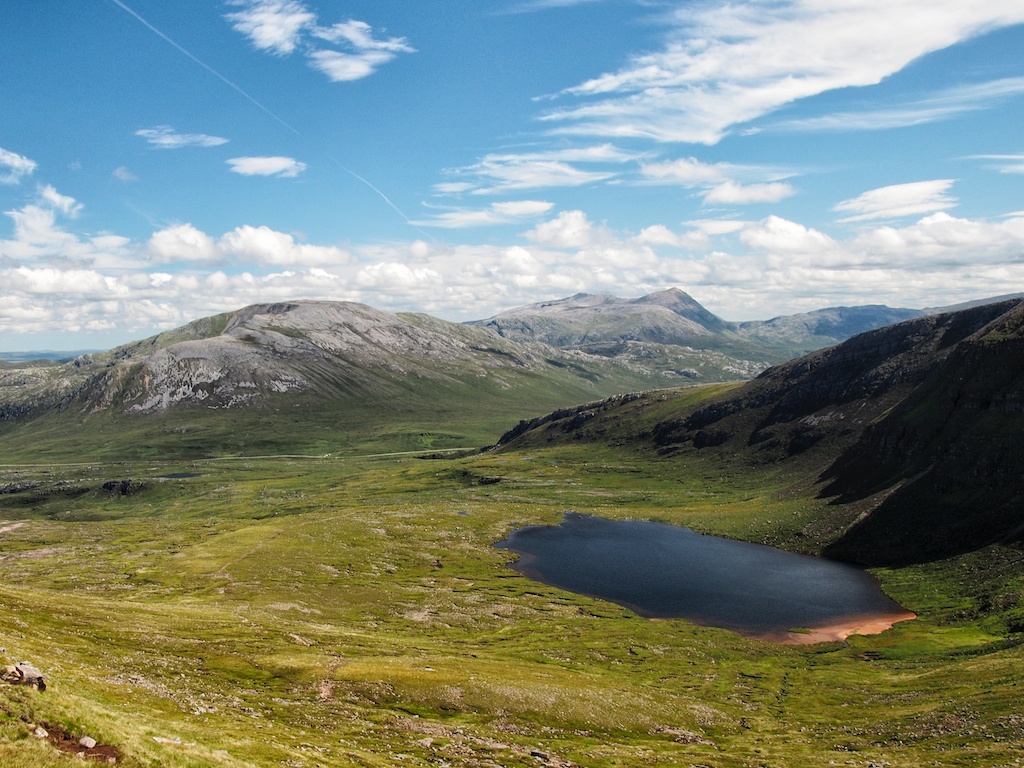
The Inchnadamph approach is really nice, the climbing steep, but nothing too difficult. Except the fact, that i chose the ascent through a very steep chimney and snowy showers on the ridge, business as usual. The walking though over quartzite stones and scree was hard. But we reached Conival in time and continued to Ben More Assynt. We descended east along a stony ridge and soon arrived at the flat summit. Since i intended to do the traverse over to Carn nan Conbhairean we stayed on the ridge.
And here the troubles began. While we had views of Dubh Loch Beag in the beginning, it was now completely out of sight. Due to this poor visibility, poor navigational skills of myself and lack of a compass we descended the wrong ridge. But i was too selfish and unexperienced to admit that i had choosen wrong. It was late in the afternoon, we had just a half litre of water and litte food left and i was not able to locate our position on the map. We started to panic a little, we hugged ourself and thought about our situation. We decided to follow the waterstreams down to the river in the distance and follow that river … there were signs of hilltracks, too. Finally we arrived at the river, followed the stream and decided to cross it. Luckily it was not in spate but none the less difficult to cross, it was quite wide (30m) and there were few stepping stones. But we accomplished that.
It was now approx. 7 p.m. and we cried of joy as we discovered that there was a building not too far away, the question was now, if it was inhabitated? We approached it and yes a woman opened the door, welcomed us and asked us into the house, without further ado!!!
We were placed along a cosy fire, were served sandwichs and coffee. Later her husband accompanied us and we began to talk. He was the gamekeeper of this estate (the owner at that time was Harrods/Fayet), this place was called Duchally and he wanted us to show where we were on our map. It occured, that we walked beyond the limits of it. After some nice talks (which included the alcoholic habits of swiss hunters) he asked us if we would like to stay the night or if he could drive us to our car at Inchnadamph. We decided not to overstay their welcome and asked for a lift to Inchndamph, which was a journey of 60 kilometres for us and 120 for him! Wow.
So we entered this old Land Rover and he drove us back. After some miles driving we passed a building, which he commented with “This is my neighbour”.
Finally we arrived at our car and we couldn’t stop to thank him.
Lessons learned
If you are not sure about your location and directions, carefully study the map!
If you are still not sure, return!
Don’t try to be a hero!
Don’t be too proud to return!
Have a compass with you!
Know how to use that compass!
Marry that woman that followed you whereever you went, regardless how stupid you were!*
* We married 1,5 years later – and still are married and have two lovely children. But we have never been up on a Munro together since that remarkable day in Assynt.
* Update 2013: We climbed Stob Binnein in August 2013 together as a family. First ever familymunro 🙂
Description These two mountains are the highest in the wild country of Assynt, situated about 6 kilometres east of Inchnadamph. On their upper slopes they are covered by rough angular quartzite stones and boulders which give quite hard walking along the broad ridges of these two hills. A feature of non-climbing interest in the area are the caves in Gleann Dubh near the River Traligill. They are worth a visit, but a torch should be taken if any attempt is made to go into them.The ascent is made from Inchnadamph, going along the track on the north side of the River Traligill to Glenbain. Continue up Gleann Dubh on the north side of the river and beyond a small wood make a rising traverse to reach the col between Beinn an Fhurain and Conival. From there climb south up the ridge of Conival over quartzite stones and scree to the more level crest leading to the summit. Descend east along a stony ridge, with one narrow section, to the flat summit of Ben More Assynt.