M156 |
989 m. |
3245 ft.
Translation: Fowling hill
Pronuncation: byn ayneech
The Munros closest to Stronmilchan are Beinn a’Chochuill and Beinn Eunaich. After a very good first night’s rest in our cottage on the right bank of the River Orchy we threw our stuff into the boot of the car and drove off to Castles farm where we parked just west of the bridge over the Allt Mhoille. We went back to the bridge, crossed it and took the landrover track leading to Castles Farm. The Angry Corrie had carried reports of rather unfriendly attitudes towards walkers which this estate had apparently shown during the FMD crisis of 2001 and afterwards. So, it was with some apprehension that we approached the farm buildings. And: Soon we saw a massive bull only 50 metres away from us outside the fenced grazing ground. Oh dear! We looked for good emergency escape routes should the bull prove to be aggressive but fortunately the animal took no interest in us and we proceeded as planned. Twohundred metres before the farm the track forks and we took the left-hand branch which steadily climbs up the hillside. Here we met a Landrover whose driver greeted us cordially. No sign of bad feelings here.
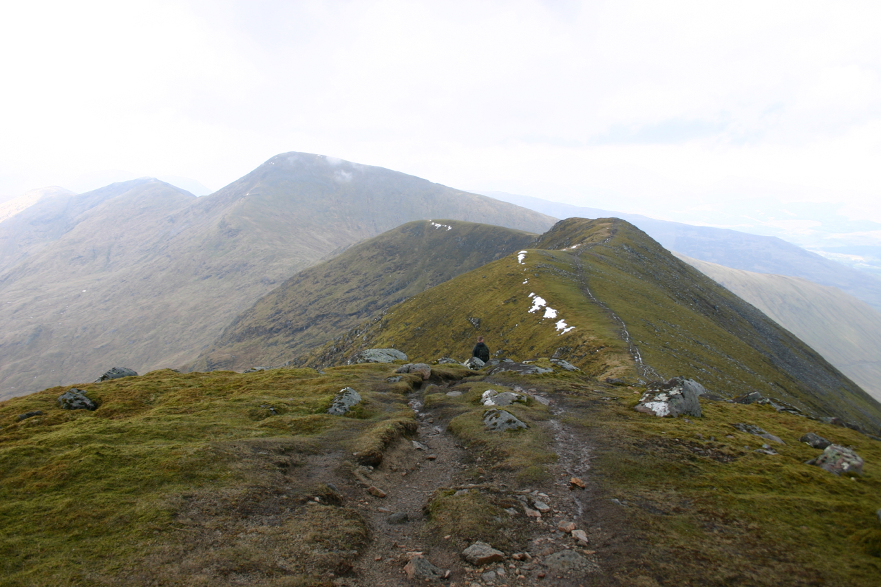
After about 200m we had to rest to drink some water and to take photographs of the Dalmally Horseshoe on the other side of the glen. After another ten minutes we passed the cairn marking the spot where the descent path from Stob Maol meets the landrover track. We continued, soon crossed the Allt Lairig Ianachain and went on to the next fork in the track where we took a right turn. After another 300 metres we left the track and started climbing the grassy and bouldery south-east ridge of Beinn a’Chochuill. This section of the climb proved to be quite steep but also manageable due to the benevolent character of the terrain. After doing zigzags for about 200m we found the path up the ridge. Enjoying the developing views of Ben Cruachan we quickly gained height on this rather uniformly steep slope. Then, the main spine of the hill came into view.
The last kilometre to the summit of Beinn a’Chochuill was a stroll along the well-defined ridge. Clouds rolling in from the east soon brought on some rain and sleet so we had to wear our rain jackets. The views of the hills to the west covered in curtains of rain gave the moment a gloomy atmosphere which was enhanced by the – rather uncommon – lack of wind. The only sounds to be heard were the splashing of rain on the ground, the crackling of hail hitting our protective plastic membranes and, after the shower had passed us, the distant sound of the rain falling in almost vertical curtains. Quaint and silent. Having watched the hills and the skies from the summit of Beinn a’Chochuill Frank and I returned along the ridge of the hill. We passed the col before Beinn Eunaich and continued up the increasingly steep ridge leading in an easterly direction to the small summit plateau of our second Munro of 9 May 2004. Exhausted as we were we rested at the cairn and ate our sandwiches. Ben Starav, Glas Bheinn Mhor, Beinn nan Aighenan, Stob Coir an Albannaich, Meall nan Eun, Stob Ghabar were all well visible from Beinn Eunaich.
Threatening cumulus clouds slowly approaching from the east reminded us of the need to get off the hill before any thunderstorms might develop. We took a few more photographs, packed our rucksack again and headed, first south-west then due south, along the broad ridge leading to Stob Maol. At a distinct bank of peat the path turned due west. The view down into the glen was impressive there since the path zigzags down a very, very steep gras slope for about 250 to 300m. A potentially dangerous slope in wet weather or after periods of extended rainfall. Slowly and carefully we proceeded along the alternatively grassy, sandy and gravelly path. Twenty minutes after leaving the ridge we got back to the landrover track of our approach route and to the cairn seen in the morning. After another short rest we headed back down the hill to Castles farm and to our car parked by the road. An entertaining ridge-walk, some amazingly steep sections on the way up and down the hills, beautiful curtains of rain in the glens and on the ridges and, last but not least, clear views of the Etive and Blackmount hills made this a hike well worth remembering.
Description These two mountains are the highest points on a long ridge running from east to west between Loch Etive and Glen Strae. Beinn a' Chochuill is a fine narrow ridge, fairly steep and rocky on its north side, but grassy on the south. Beinn Eunaich is a more compact mountain with three well-defined ridges converging at its summit. The two mountains are well seen from the Strath of Orchy near the head of Loch Awe. The traverse of the two is best done from the foot of Glen Strae. Follow the track which bypasses Castles Farm and climbs across the south-west side of Beinn Eunaich. Shortly after crossing the stream which flows down between the two peaks climb north up grassy slopes which gradually steepen and lead to the main ridge of Beinn a' Chochuill just less than 1 kilometre east of its summit. The last part of this ridge is fairly level.Return along the ridge to Beinn Eunaich, and climb its west ridge which becomes steeper and rockier in its upper half and leads directly to the summit. Go south along the ridge leading to Stob Maol and before reaching the rocky lower part descend on its west side to regain the track above Castles Farm.