M168 |
981 m. |
3219 ft.
Translation: Bald red head
Pronuncation: moel chan dyerack
Doing things differently than the rest is the privilege of the unexperienced. Or it may simply be the result of independent thinking based on the desire of maximising one’s advantages. Since we were staying in Invergarry we considered ways of climbing the South Glen Shiel hills from the Loch Quoich side. This would save us quite some time driving over to Loch Cluanie and further to Glen Shiel AND we would not have to walk along the trunk road on our way back from the hills. Thus the plan was born to climb Aonach air Chrith, Maol Chinn-dearg, Sgurr an Doire Leathain, Sgurr an Lochain and Creag nan Damh from Alltbeithe.
Well, we parked our car at the road side just behind the bridge crossing the narrow northern arm of Loch Quoich. The land rover track on the west side of this nothern part of Loch Quoich made for easy and quick access to Alltbeithe which is located very nicely near the confluence of the Wester and Easter Loch Quoich Burns. Past Alltbeithe we turned due east and walked the track/path for about two kilometres. Then, after some slight problems locating the stalkers path that climbs up the steep hillside to the north, we finally found the very well-engineered zigzag-path which steadily weaves its way up about 550 to 600 metres to the South Glen Shiel Ridge. We made good progress and soon the ridge was gained. I chose to take nap there and let Frank bag Aonach air Chrith alone since I had already had the privilege of visiting this hill with Mike years ago. While Frank was on his jogging exercise to this fine Munro, I really dozed off until I was re-awakened by some Scotsmen who also took a break at the beallach. We chatted a bit and ate some cookies.
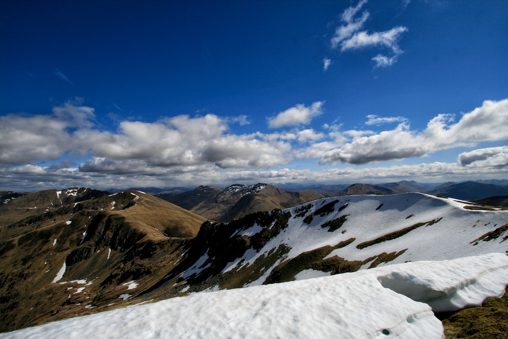
Soon Frank came back and together we headed on to Munro No. 2, Maol Chinn-dearg. Again this one was in my bag already from years ago. Nonetheless it’s always nice to touch a summit cairn. Then Sgurr an Doire Leathain beckoned and we were on our way again quickly. The cairn of this third Munro is on a spur ridge jutting out to the north. Here some snow fields were still left over from the winter. From the cairn we then continued on the main ridge towards Sgurr an Lochain. This stretch was interesting and the views down into the glen were more varied due to the loch which gives Munro No. 4 its name and the hill itself which has nice cliffs. From the summit we carried on along the ridge and bypassed Sgurr Beag to finally reach the wide col at 760 metres. From there it was a final and interesting pull up the rocky southeast ridge of Creag nan Damh. At the summit of this fifth Munro of the day we had a real long break enjoying the views and eating some apples in the sunshine. However, a strongish wind was blowing and we had to walk back another 10 kilometres to the car. So we shouldered out rucksacks, walked back to the col and picked up another very nice stalkers path which winds its way back into Glen Quoich and the track at the valley floor. Then it was an easy walk back to Alltbeithe and from there back to the car by Loch Quoich. An uncommon approach to the ridge and a rather satisfying and beautiful day in the hills. Scotland at its best!
Description The mountains on the south side of Glen Shiel form a continuous chain 15 kilometres long, its seven Munros linked by a high ridge which gives one of the best long high-level traverses in the Highlands. The north side of this ridge consists of a series of fine corries separated by spurs, most of which give easy access from Glen Shiel onto the several peaks of the South Glen Shiel Ridge, as these mountains are collectively known. The south side of the ridge above Glen Quoich is a long and continuously steep hillside which does not offer any attractive routes of ascent. Consequently these mountains are almost always climbed from Glen Shiel to their north, using some good stalker's paths up the corries and projecting spurs. Although it is possible to traverse the entire ridge in an excellent long day, the following descriptions treat it in two halves, the eastern section of four peaks and the western section of three.The best way to start the eastern half of the ridge is to walk from Cluanie Inn up the old road which used to lead to Tomdoun. From a point 1 kilometre beyond its highest point follow a stalker's path up the south-east ridge of Creag a'Mhaim. From there the traverse continues west without any difficulty, following the ridge-crest over Druim Shionnach and Aonach air Chrith to Maol Chinn-dearg. The descent goes north-east down an easy grassy spur, at the foot of which an old stalker's path leads to the A87 road in Glen Shiel about 3 kilometres west of Cluanie Inn.