M26 |
1132 m. |
3714 ft.
Translation: White hill
Pronuncation: gyal chaarn
1 June 2014 was my (Cord) 49th birthday and Frank had a special present for me in store: The four Munros of the Geal Charn Group from Culra. But first we needed to get there.
So the morning saw us unloading our bicycles from the car at Dalwhinnie station, shouldering our rucksacks, crossing the railway line and starting the long cycle trip to the bothy. The long track along Loch Ericht held nothing new for us since we had already used it the day before when we had climbed Ben Alder. Frank was out of sight quite quickly. My wobbly legs did not permit too much effort to be put into the 15 to 16 km leg to Culra. When I arrived there quite a while later than my companion it started to drizzle. Rats. It was to be only a short shower, however.
We then embarked upon the walk towards the Bealach Dubh which is on a very well-maintained path that makes progress easy. We skipped the Lancet Edge (my wish, a birthday has got to be good for something, you know) and soon found ourselves at the bealach which we crossed without a pause. Then we continued for a short while along the path down into the next glen. When we were past Sron Ruadh we quit the path crossed the stream and climbed into Coire a’Charra Bhig. This is a grassy corrie holding a burn with a steeply flanked bed in the upper corrie. Staying on the left bank of the stream makes life easier considerably for the wary hiker. Frank did so, I did not: another birthday present for me.
Once on the ridge we turned left (west) and headed for Beinn Eibhinn’s long curving summit ridge a kilometre away. There are two cairns on this level ridge and to be sure we visited and touched them both. The books later confirmed that this was right since it is of course the one further to the west (or more precisely to the north) which is the “real” summit. From Beinn Eibhinn we retraced our steps to the bealach between this Munro and Aonach Beag. Soon Munro No.2 was bagged as well. Unfortunately there were no views as clouds shrouded the mountain tops most of the time. But a strong wind was blowing that kept us going alright and at a brisk pace so that the body heat might counteract the wind chill.
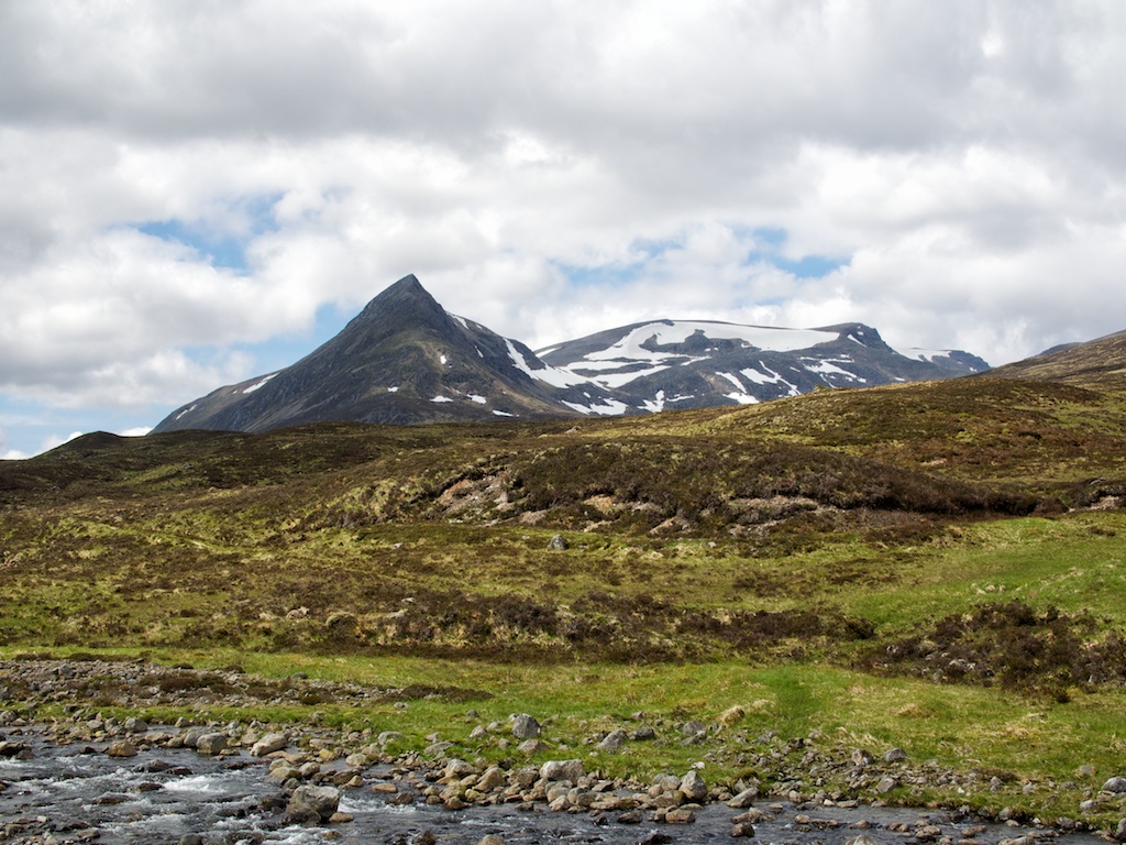
Then the Geal Charn Plateau was at hand and the summit cairn appeared from the clouds before us. The Cairn was touched and on we went towards Carn Dearg a mere four or five kilometres away. With the help of map and compass (and the occasional glance at the GPS) we easily found the rocky rib (or ridge) separating Loch Coire Cheap (left) and Loch an Sgoir (right). The descent down this rocky ridge was fun but since there were vestiges of snow left on the steep part caution was called for. From the ensuing bealach we crossed the bump of Diollaid a’Chairn and finally tackled the very rocky summit slopes of Carn Dearg. Boulder hopping in the mist (no gorillas though). At the summit we rested for a few minutes and then continued our epic hike going down the grassy northeast ridge of Carn Dearg. Once this levels out at a very wide col we turned in a more southerly direction and descended increasingly steep slopes of heather and rocks towards Culra bothy in the glen deep, deep down below. Me being quite knackered by that time this last part of the decent felt like real fun. Another birthday treat! 🙂
At the bothy we rested our tired limbs, ate our last sandwiches and drank a lot of water. I would have gladly given away my grandmother’s silver cutlery for one simple can of ice-cold Coca Cola. Then the last leg of this trip needed our attention: the bicycle ride back to Dalwhinnie. Frank set off like a young god. I felt more like a wet towel. Anyway, in due time I also arrived at Dalwhinnie where Frank had been waiting for me for quite a while. With this arrival back in railroad country a truly epic, entertaining and memorable Munro-bagging trip was over. I shall never forget my 49th birthday. Thanks for being a good buddy, Frank, and keeping me company!
Description These two mountains are the north-eastern half of the long ridge in the heart of the central highlands extending from Loch Ossian to Loch Pattack. They form a continuation of Beinn Eibhinn and Aonach Beag towards Loch Pattack . The summit of Geal-Charn is a large flat plateau with big corries to its north and north-east. Between these corries a narrow ridge extends north-east to Carn Dearg, and another ridge goes east to the sharp-pointed peak of Sgor Iutharn. These are remote mountains, and any approach to them involves a long walk or possibly the use of a bicycle along the tracks that lead into the hinterland from Dalwhinnie, Glen Spean or up the River Pattack.The most usual approaches are from the north, one starting at Dalwhinnie and going by Benalder Lodge to Loch Pattack and the other going from the east end of Loch Laggan up the River Pattack to Loch Pattack. From there continue along the Allt a' Chaoil-reidhe past Culra bothy and 3 kilometres beyond there climb west up the narrow ridge of Sgor Iutharn to reach the eastern edge of the Geal-Charn plateau. Go west across the plateau to the summit. Return north-east and descend the narrow ridge leading to Carn Dearg. From the summit of that hill descend east to Culra.The northern approach from Glen Spean probably involves more effort, going from the south-west end of Loch Laggan to Lubvan, possibly by bicycle, and then walking up the Allt Cam to the Dubh Lochan before climbing the northern slopes of Geal-Charn.