M247 |
933 m. |
3061 ft.
Translation: Bald red head
Pronuncation: moel chan dyerak
The last hill tour of the 2015 “campaign” was the bare red headed hill of the Ben Damph / Coulin Forrest. Frank and I parked the Volvo at the lochside layby in Annat. While getting our things together we were joined by a mountain biker who also wanted to head for Maol Chean-dearg. We chatted a bit and after some “see you later” we set off behind him.
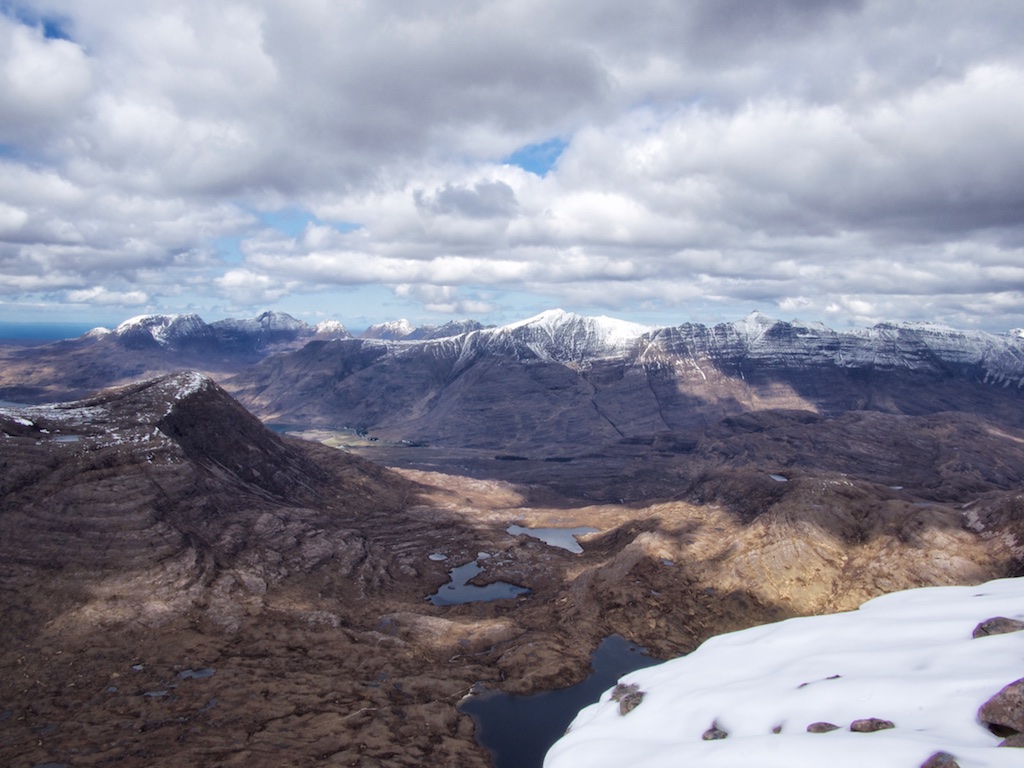
I (Cord) had already climbed Maol Chean-dearg from Annat in 2000 so the good path on gravel and over slabby terrain was kind of familiar. It climbs to an altitude of about 300m and then levels off when it reaches the flat terrain characterized by slabs, sand and two or three small lochans lying between Beinn na h-Eaglaise and Meall Dearg. Having passed Lochan Domhain we soon came to the banks of Loch an Eion. From there the north face of Maol Chean-dearg was quite an impressive view both ahead and also as reflected in the loch.
Again as I had done in 2000 we took the right-hand fork and followed the path around the west and later south flank of the hill towards the beallach between Maol Chean-dearg and An Ruadh Stac. This path rises steadily and more or less gently towards Loch Coire an Ruadh Stac and further on to a small round lochan with whitish quartzite walls that nestles nicely between the two hills. Here we again met “our” mountain biker who had embarked on the trip back to the car.
At the 590m beallach we had our second break of the walk and ate sandwiches basking in the sunshine. We left our rucksacks at the beallach and started the stiff climb up the steep 150m of the ridge consisting of quartzite and quartzite scree. From my memory I knew that a more level section would follow that also has a lot of quartzite slabs standing upright due to folding. Here snow covered the ground in some spots.
Then the terrain became grassy underfoot for a few hundred metres before the final steep boulder slope (quartzite and sandstone) had to be tackled. There was more snow here and we needed to be careful not to step into gaps between the boulders. But then the summit came into view as the snowy plateau opened up before us. At the large summit cairn we enjoyed panoramic views of all of Torridon, Beinn Damh and Coulin. A mighty great day. Soon a summit chat with a German lady Munro bagger added to the entertainment the hill offered.
The return to Annat meant retracing our way of ascent to the beallach where our “baggage” lay, having another snack there and then shouldering the rucksacks for the ten kilometre hike back to the shore of Loch Torridon. We fell into quite a speedy trot which made us to do the return leg of the hike in slightly less than two hours with only one or two short breaks needed to drink some well-deserved sips of water from our bottles.
We arrived at the lochside after six and a half hours with the sun still shining upon us. There had been hardly any precipitation the whole day. Perfect for a change. The days before had seen us face a number of definitely wintry showers indeed. This hike was a nice and easy end to the hill-walking of April 2015. The next day we did a nice coastal walk north of Gairloch. But that’s another story. Haste ye back to Alba in 2016!
2000 Staying at Lower Diabaig I decided not to climb this hill from the south as recommended in the SMC book The Munros but to approach it from the north from Annat, one mile south/west of Torridon village junction on the A 896 road. Climbing up steadily from the starting point the path soon reached the plateau beneath Beinn na h-Eaglaise and continued to the north eastern end of Loch an Eion. There I took the right-hand fork where the path around the western and southern face of Meall Chean-Dearg branches off. After some easy walking and a steady ascent I came to the 590 m-bealach between the hill of the day and An Ruadh-Stac. Having walked 10 km in two hours I took a break, had a rest and looked at the western face of Sgorr Ruadh on the opposite side of the Fionn-abhainn. From this bealach I climbed the ridge up to Meall Chean-Dearg’s shoulder over quartzite scree and quartzite slabs standing upright. The final 100 m in height were a steep slog up the red sandsone boulders to the summit plateau of the hill. There I rested and marvelled for a short time at the sight of Liathach and Beinn Eighe who appeared to be one ridge from there. Alas, rain approaching from a west-south-westerly direction forced me off the summit all too soon. I walked back along the south/east ridge of the hill to the beallach at 590 m in rain and headed my way back to Annat, the ran having set in more persistently. It subsided, however, and I was easily walking back to Loch an Eion when a tall and strong stag crossed my way. He was certainly more shocked at my sight than I was at his and he sped away in enviable hill climbing style. What modest creatures we are when it comes to moving in boggy and bouldery highland terrain. Eventually I got back to the start of my hike after a little more than five and a half hours and I met Stephanie and Fiona for a very enjoyable meal and some drinks at the bar of the Torridon Hotel just a few hundred meters along the A 896. 20 km are a longish day out for one munro of perhaps not all that much Torridonian character. And although the approach from the north is through beautiful landscape scenery I presume that the shorter tour from the south is preferable.
Description Maol Chean-dearg is a rather isolated mountain in the Coulags Forest, separated from its neighbours by a col at just below 600m. Around its northern and western perimeter it is well defended by crags, but to the south-east a broad stony ridge gives an easy ascent. The route from Glen Carron to Maol Chean-dearg starts from the A896 road near Coulags Lodge and goes along the right of way on the east side of the Fionn-abhainn for 4 kilometres, then turns left up the stalker's path to the col at the foot of the south-east ridge. Climb this ridge, there are traces of a path at first, but higher up the bouldery nature of the terrain hides any signs of a path.