M161 |
987 m. |
3238 ft.
Translation: Gaelic gaorr (filth) or gaoir (noise)
Pronuncation: goolvan
June 2016 saw us climb some very nice hills. Our cottage was located more or less centrally in Roy Bridge and we bagged what was left to be done for us in the Grey Corries, in Kintail, by Lochs Arkaig and Eil. 15 June was the day for Gulvain, a solitary hill well hidden from roadside views: Even on fortunate days which boast clear skies and sunshine. A privilege we definitely did not enjoy since the weather was rather – how am I going to put it – adverse. We parked our car in the vicinity of the A830/A 861 junction. The A 861 had been one of our connections to civilization in 1998 when we had spent three (!) marvellous (!) weeks in Glenborrodale in Ardnamurchan. There our plan to climb all the Munros had first taken shape during a sunny and warm September holiday, by the way.
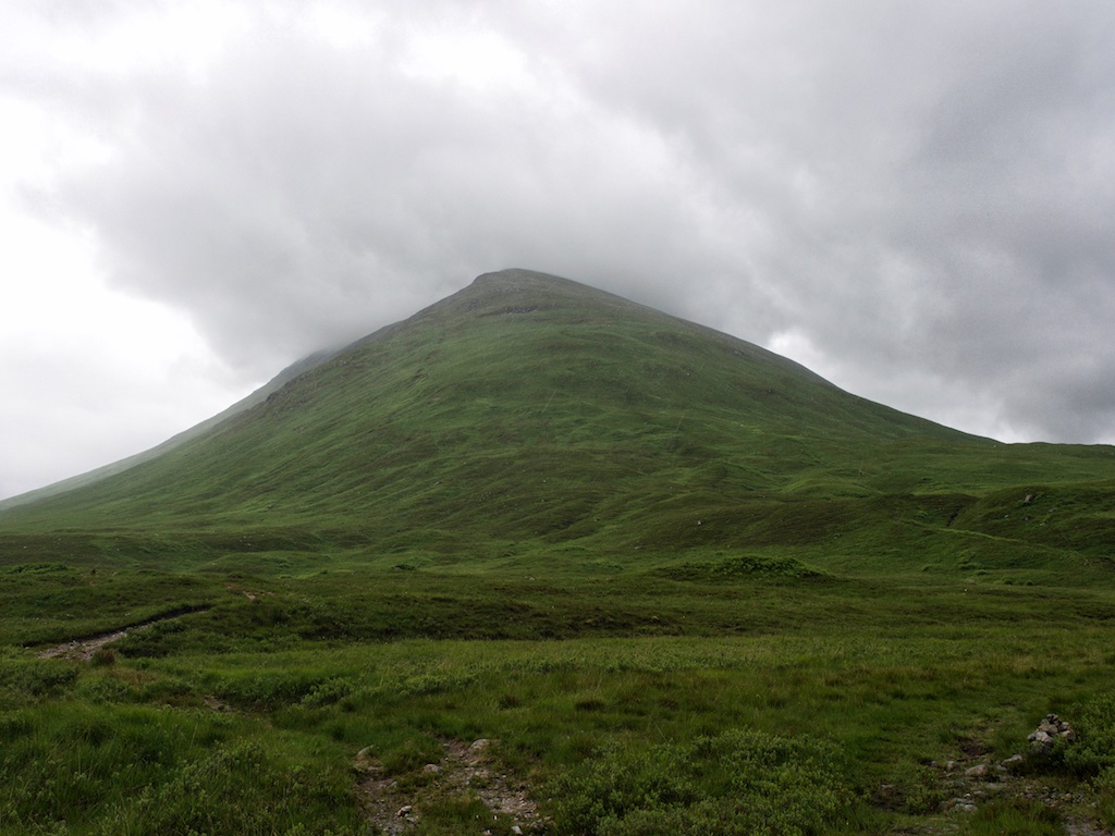
No such gentle conditions today: All raingear went on at street level. There was a stiff wind and the occasional blustery shower that had to be braved. Our hike to Gulvainís foot took us for about 6 km along the Landrover track up Gleann Fionnlinghe. The lower reaches of the glen are wooded and quite nice. You pass Wauchan cottage, then leave the forest two kilometres onwards and continue on the rough track for maybe another two kilometres to Gulvain. The path up the uniformly steep and grassy southwest ridge (see photo) is obvious and well-trodden, if a bit squishy at the start. The more height is gained the more the grass disappears and gives way to stones, gravel, sand and rocks. But the way ahead is always obvious and route-finding is no problem even in the thickest of clouds which, incidentally, we had the expected pleasure of encountering on the higher slopes of the hill.
Even though it was a very windy and wet day the hike up this ridge had seen us walk in the lee created by the whaleback of the hill. Once the southwest ridge levelled off at point 855m we were struck head on by gale-force winds which literally blew us over several times. The way ahead to the South Top of Gulvain was an epic struggle which saw us fighting against the ferocious wind on the stony terrain. Unaware of us being quite close to the South Top we lay down on a grassy spot behind some low band of rock and waited for ten minutes for the wind to pause for at least a moment. But to no avail. Then, with strength and determination regained we made the final push to the South Top and pressed on from there. Once this pre-summit was behind us the wind fell almost silent. We walked along the narrow ridge in an eerie mood which felt as unnatural as the fight against the howling wind just a few minutes ago. The modest climb to Gulvain’s 987m summit was easy and soon we reached the big cairn. There we rested but a few minutes: No views. Just wind and clouds.
So we retraced our steps to the South Top, stumbled down the ridge to Point 855m with the gale driving us onward now instead of nailing us to the ground and then gladly left the summit area of Gulvain behind as we began the descent down the long southwest ridge. Before we reached the glen we stripped off one or two layers of fleece that had kept us warm against the massive wind-chill and we took off our gloves.
Now all that was left to us was the long walk back down Gleann Fionnlinghe. This was an easy stroll in moderate rain and blustery wind. But we were upbeat since we knew were safe now from the wild forces of nature we had had to brave 700m higher up. Wauchan cottage came and went. We re-crossed to the orographically left side of the Fionn Lighe and completed the last 2.000 metres to the car in almost calm and dry weather.
Back at the car, we took off the Gore-Tex clothes and boots to immediately find us in the fresh wind in completely damp clothes and soaked socks. No wonder we did not linger but threw all the wet gear into the boot of the car, slammed close the doors (with us inside the car, mind you) and set off towards Glen Roy with the heating and air conditioning fighting hard against all the humidity we gave off.
So, what’s the score? A long and wet but nice approach, a slog up a steep ridge and a sound battering at the top. It could have been much worse still, it could have snowed. And one more tick in the list, thank you!
I don’t think I’ll return to Gulvain any time soon but there’s this neighbour, Streap, which we definitely should pay some attention to the next time we are around with some time to spare. And the weather will definitely be better! As my grandma said: There’s always hope.
Description Gulvain is a remote mountain at the head of Gleann Fionnlighe between the head of Loch Eil and Loch Arkaig. It is the highest mountain in this area of West Lochaber and it forms a high ridge running from south-west to north-east with the summit at the north end and the prominent south Top at the other end. On both sides, particularly towards the west, the slopes of the mountain drop very steeply into the surrounding glens.The usual route of ascent is from the A830 road near the west end of Loch Eil. Go up the track in Gleann Fionnlighe, initially on the east side of the glen, then crossing to the west side to reach the footbridge across the Allt Choire Reidh. It is possible to cycle for most of the way. Once across this stream, climb north-east up unrelenting grassy slopes which seem to go on for ever. At last a knoll is reached and ½ kilometre beyond it is the South Top. Descend along a broad grassy ridge and climb again to the summit of Gulvain. The return is by the same route.