M157 |
989 m. |
3245 ft.
Translation: White peak
Pronuncation: skoor bawn
A repeat. At least most of the tour was a repeat of what we did two years ago when we climbed Beinn Tarsuinn. You see, the approach to these three Munros is definitely the longest bit of the tour and the really hilly part of the tour is not that long. Then, on the last day in April 2015, conditions had been quite wintry with slushy, powdery, compacted or icy snow underfoot depending on the aspect of the hill and the altitude you were at. That day we had not been able to add Mullach Coire Mhic Fhearchair and Sgurr Ban to our tick list.
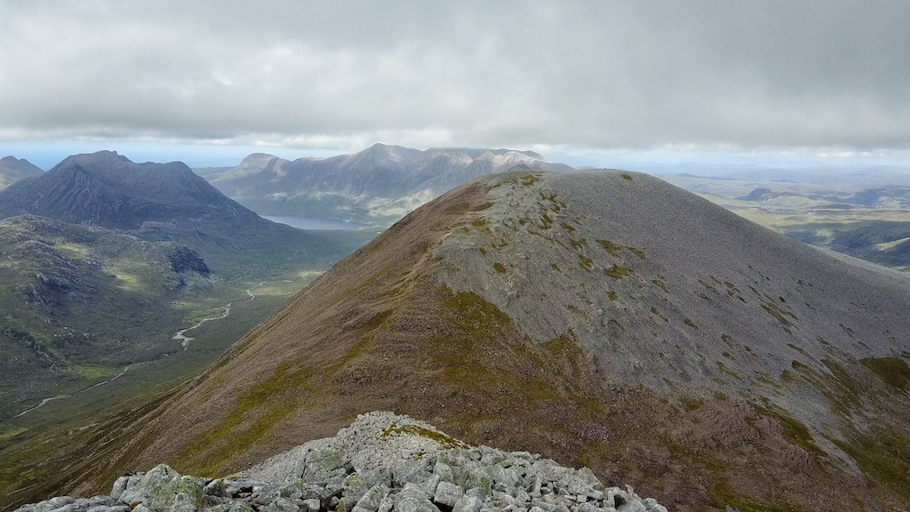
On 7 June 2017 the conditions were different since there was no snow left anymore this late in spring. But again like 25 months ago we left our bicycles at the Heights of Kinlochewe. Again we climbed the Landover track beside the Abhainn Gleann na Muice and gained the open moor. Just as in 2015 the hike to Lochan Fhada offered great views of Slioch’s north-west aspects, of Beinn Tarsuinn, Meall Garbh and Mullach Coire Mhic Fhearchair. At least when the hills peeped out from the rain clouds.
But the ground was reasonably dry, even though there had been rain and some showers very recently, when we picked up the faint track leading through grass and over some slabby sections all the way from the shore of beautiful Lochan Fhada to the Bealach Odhar. We reached the bealach and sat down in the lee of some rocks to enjoy the views of A’Mhaighdean and Ruadh Stac Mòr in the sunshine. Then without further ado we continued along the bypass path below Meall Garbh and reached the foot of the steep south ridge of Mullach Coire Mhic Fhearchair.
This is quite some climb, the first 120m of which led over and around huge slabs and rocks made of red sandstone displaying some beautiful examples of woolsack weathering. Then the sandstone abruptly gave way to big white quartzite boulders through which and over which a faint track climbed all the way to the short summit ridge of this highest hill in Fisherfield.
At the cairn we talked to an English hiker who had climbed the hill along the same route as us. We spent some time on the summit and waited for the mist and clouds to lift, which they did from time to time. Then we said goodbye to the solo hiker, left our rucksacks near the summit and embarked on the steep descent towards the bealach between Mullach Coire Mhic Fhearchair and Sgurr Ban. This was the steepest section of the whole hike but the steepness made short work of the descent. From the col the climb to Sgurr Ban was over much more easy-angled slopes. The summit plateau of Sgurr Ban greeted us with loads of (of course) white rocks and a large cairn at the far end of the very flat mountain top.
With our gear dropped near the summit of Mullach Coire Mhic Fhearchair the return leg of the hike was a rerun of the outward leg in reverse order. The very steep climb back to the Mullach took a little longer than the swift descent an hour earlier but never mind. After some drone-flying exercises performed by Frank at the summit the rest of the hill walk was accomplished without problems by retracing our steps all the way back to the bikes at the Heights of Kinlochewe and then to our car at the Incheril parking.
This walk is long and much of it is ordinary footwork. But the grandeur of the setting and the boldness of Mullach Coire Mhic Fhearchair amply compensate for the shoe-leather effort spent getting to Lochan Fhada and back. Not many mountains in Scotland offer better views in remote back-hill country than this Hill of the Corrie of Farquhar’s Son!
Description Sgurr Ban is a very rough and stony mountain 1,5 kilometres north of Mullach Coire Mhic Fhearchair in the eastern part of the Fisherfield Forest. The upper part is almost entirely covered with quartzite boulders whose pale grey appearance give the mountain its name and give the hillwalker some very rough walking. Low down on the east side of Sgurr Ban on the slopes above Loch an Nid there are some extensive areas of bare quartzite slabs set at an easy angle, ideal for padding up when they are dry, but beware when they are wet.Sgurr Ban is a long way from any starting point on a public road. It might be climbed with Beinn Tarsuinn and Mullach Coire Mhic Fhearchair from Kinlochewe, or with Beinn a' Chlaidheimh from Corrie Hallie, but these are both very long days. The shortest approach to the mountain is from the A832 road 6 kilometres from Braemore Junction at the point where a track leads to Loch a' Bhraoin. Follow this track and the path south-westwards along the side of the loch, past Lochivraon bothy and 3,5 kilometres further west to the strath of Loch an Nid. Cross the strath and climb west then north-west up the bare slopes of Sgurr Ban. In places it is possible to pad up the easy-angled slabs to the quartzite boulder field of the summit.