Bla Bheinn (Blaven)

The best day, at least weather-wise, was also the last day of the 2016 holiday in Scotland. After five days of fog, two days of wind and rain and one further beautiful day this hike was the saving grace of an otherwise rather viewless bagging season.

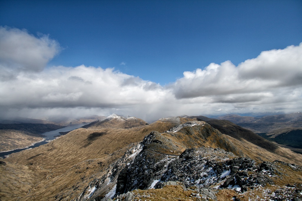
Knowing the weather would be very good we had decided to climb Blaven via its south ridge since this would afford us marvellous views of the Black Cuillins on the way up. Like quite a few other walkers we started the hike from the parking south of Kilmarie where a Landrover track crosses the Strathaird peninsula. The track undulates a bit but then rises to its highest point (Am Mam) and drops again on its way towards Camasunary. Shortly before the next sharp bend in the track a path leads off towards the foot of the south ridge of Blaven. In due time this path crosses a small burn. A few metres past the burn the path leading up the steep grass slopes of the mountain’s south ridge branches off at an altitude of approximately 100m.

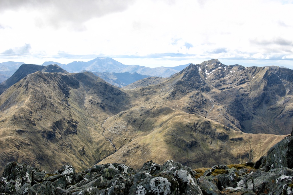
We climbed this very steep slope on the good path which further up outflanks the first bands of rock to the right before it leads up a steep gully filled with scree. Then at about 380m the path suddenly reaches the crest of the ridge and the complete Black Cuillin ridge springs into view. I took a break there and enjoyed the views which really were to die for.

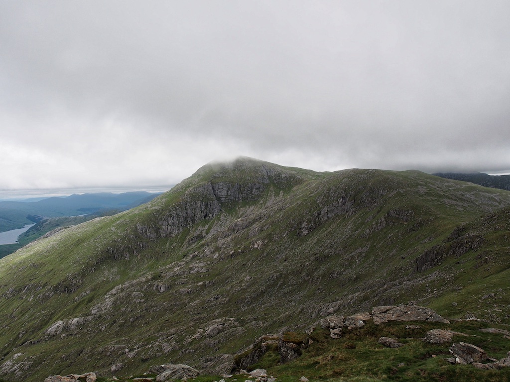
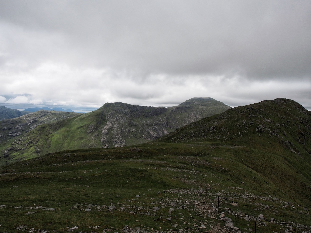
From this spot onwards there is not much grass left underfoot as slabs of rock, small boulders and scree form the ground your boots tread on. The way forward was marked by cairns though and route-finding was not a problem. Over several steps in the ridge – which gave opportunity for some mild scrambling – the path follows the crest of the ridge or uses easier terrain on the east side of the hill. Further up the mountain it was not so easy to discern a path or rather the right path … [Read More]

2017-09-19T14:14:57+02:00June 18th, 2016|2016, 2019 - 2010, The Islands|

Beinn Fhada

17 June 2016 was the last but one day in the 2016 hiking season. We had packed all our stuff into the car and had quit our quiet cottage in Glen Roy not too early in the morning. The drive up to Glen Shiel and then to Loch Duich had been swift, pleasant and uneventful. There wasn’t too much activity at the Morvich outdoor centre and camping spot that Friday morning. We set out towards Strath Croe first walking on the road and then, after crossing the Abhainn Chohaig, along the signposted and well-maintained footpath. It was a warm day. Soon a thin film of sweat appeared on our faces and forearms. We passed the grassy area below the steep face of Beinn Bhuide and entered Gleann Choinneachain.

I had been there several times before and remembered that the very convenient and well-maintained path climbs steadily and very gradually into the beautiful glen. Some pools and small waterfalls seemed quite inviting — if difficult to reach — from the high path. When maybe six or seven kilometres had been covered we reached the spot where the path towards Beinn Fhada branches off. Thereabouts we dropped our rucksacks and continued towards Bealach an Sgairne since we wanted to climb A’Ghlas-bheinn first. On the next kilometre the path leading to the bealach winds its way through and over boulders in the ever-narrowing glen. Quite interesting.

From the bealach we could not see much in the direction of the Affric hills since some clouds blocked the view. A pity. But the close-up details of the craggy and steep north face of Meall a’Bhealaich compensated a bit for the lack of grand vistas towards the east.

The continuation of the remaining 350m climb to the summit of A’Ghlas-bheinn was entertaining. First the path climbs steeply through rocky terrain broken by grassy terraces. Once some further height is gained the path more or less sticks to the top of the grassy ridge which rises in several rocky steps followed by flatter sections towards the summit of the 918m … [Read More]

2017-09-19T14:14:57+02:00June 17th, 2016|1998, 2016, 2019 - 2010, Glen Affric and Kintail|

A’Ghlas-bheinn

17 June 2016 was the last but one day in the 2016 hiking season. We had packed all our stuff into the car and had quit our quiet cottage in Glen Roy not too early in the morning. The drive up to Glen Shiel and then to Loch Duich had been swift, pleasant and uneventful. There wasn’t too much activity at the Morvich outdoor centre and camping spot that Friday morning. We set out towards Strath Croe first walking on the road and then, after crossing the Abhainn Chohaig, along the signposted and well-maintained footpath. It was a warm day. Soon a thin film of sweat appeared on our faces and forearms. We passed the grassy area below the steep face of Beinn Bhuide and entered Gleann Choinneachain.

I had been there several times before and remembered that the very convenient and well-maintained path climbs steadily and very gradually into the beautiful glen. Some pools and small waterfalls seemed quite inviting — if difficult to reach — from the high path. When maybe six or seven kilometres had been covered we reached the spot where the path towards Beinn Fhada branches off. Thereabouts we dropped our rucksacks and continued towards Bealach an Sgairne since we wanted to climb A’Ghlas-bheinn first. On the next kilometre the path leading to the bealach winds its way through and over boulders in the ever-narrowing glen. Quite interesting.

From the bealach we could not see much in the direction of the Affric hills since some clouds blocked the view. A pity. But the close-up details of the craggy and steep north face of Meall a’Bhealaich compensated a bit for the lack of grand vistas towards the east.

The continuation of the remaining 350m climb to the summit of A’Ghlas-bheinn was entertaining. First the path climbs steeply through rocky terrain broken by grassy terraces. Once some further height is gained the path more or less sticks to the top of the grassy ridge which rises in several rocky steps followed by flatter sections towards the summit of the 918m … [Read More]

2017-09-19T14:14:57+02:00June 17th, 2016|2016, 2019 - 2010, Glen Affric and Kintail|

Sgurr Choinnich Mor

Roughly four years after Frank had bagged Sgurr Choinnich Mor in one go with Sgurr Ban and the Grey Corries, June 2016 saw us return to Glen Nevis so that I could bag the Big Mossy Peak as well. It was a damp and overcast day with massive clouds clinging to the Munros all the time, so when we set off from the parking at the Nevis Gorge we did not expect to enjoy panoramic views from the summit of Sgurr Choinnich Mor.

The approach path to the hill of the day was of course well-known to Frank and me since we had been there at least four or five times before. Nonetheless it is always worth the while to come back to this beautiful spot after a few years and to see the gorge and the hills again. As usual we made good progress and soon reached the flats where the Water of Nevis meanders. The Falls of Steall boasted quite some water since there had been no real shortage of rainfall the days before. Very white and very beautiful. We pressed onwards and soon reached Steall ruin where the path towards Carn More Dearg and Aonach Beag branches of to the left.

Now we made the first steps on new terrain but the path continued onwards in a steady fashion: Well-engineered, mostly dry and very easily angled. After another two kilometres on the path we headed for the hill walking on a faint grassy path that clung to a stream coming down the hill from the environs of the col between Stob Coire Beallaich and Sgurr Choinnich Beag. We gained height very steadily. Soon we had to make a decision as to whether we wanted to include Sgurr Choinnich Beag in the hike or head for the col between that hill and Sgurr Choinnich Mor. The faint path that kept appearing and disappearing took the decision for us since it lead to a height of about 600 or 650 metres and disappeared. It had deposited us due south of Sgurr … [Read More]

2020-12-17T16:40:35+01:00June 16th, 2016|2012, 2016, 2019 - 2010, Loch Linnhe to Loch Ericht|

Gulvain

June 2016 saw us climb some very nice hills. Our cottage was located more or less centrally in Roy Bridge and we bagged what was left to be done for us in the Grey Corries, in Kintail, by Lochs Arkaig and Eil. 15 June was the day for Gulvain, a solitary hill well hidden from roadside views: Even on fortunate days which boast clear skies and sunshine. A privilege we definitely did not enjoy since the weather was rather – how am I going to put it – adverse. We parked our car in the vicinity of the A830/A 861 junction. The A 861 had been one of our connections to civilization in 1998 when we had spent three (!) marvellous (!) weeks in Glenborrodale in Ardnamurchan. There our plan to climb all the Munros had first taken shape during a sunny and warm September holiday, by the way.

No such gentle conditions today: All raingear went on at street level. There was a stiff wind and the occasional blustery shower that had to be braved. Our hike to Gulvainís foot took us for about 6 km along the Landrover track up Gleann Fionnlinghe. The lower reaches of the glen are wooded and quite nice. You pass Wauchan cottage, then leave the forest two kilometres onwards and continue on the rough track for maybe another two kilometres to Gulvain. The path up the uniformly steep and grassy southwest ridge (see photo) is obvious and well-trodden, if a bit squishy at the start. The more height is gained the more the grass disappears and gives way to stones, gravel, sand and rocks. But the way ahead is always obvious and route-finding is no problem even in the thickest of clouds which, incidentally, we had the expected pleasure of encountering on the higher slopes of the hill.

Even though it was a very windy and wet day the hike up this ridge had seen us walk in the lee created by the whaleback of the hill. Once the southwest ridge levelled off at point … [Read More]

2017-09-19T14:14:57+02:00June 15th, 2016|2016, 2019 - 2010, Loch Eil to Glen Shiel|

Sgurr na Sgine

On 14 June 2016 we had something very special on the agenda. Special because the tour included the first Munro I had ever climbed: The Saddle, in 1993. And special, too, as the day would see us climb Sgurr na Sgine the only Munro that had seen me turn back from it twice, both times in driving snow in winter 1997/1998. So I was utterly determined to finally bag the Hill of the Knife 18 years on.

We started the hike at the layby on the A87 in Glen Shiel and followed the path leading to the foot of the steep north-east ridge of Faochag. Once we had crossed the Allt Mhàlagain we turned right and headed towards the path leading up to Meallan Odhar. I admit that was a somewhat spontaneous approach but we had been too bloody stupid to pick the old military road earlier on. Ok, no harm done. Once we had reached the Meallan Odhar path it was a steady plod up this hikers’ highway until finally the shoulder between Biod an Fhitich and Meallan Odhar invited us to have a break and to drink some water. The view towards the Forcan Ridge and the Saddle was to die for. But dying was not high on our list of things to do. So instead we continued on the path bypassing Meallan Odhar’s summit which leads to the foot of the Forcan Ridge.

What can you say? The first time I had been there was in 1993 also with Frank. The climb up the ridge had been a dance up the crest. The Forcan Ridge still was real fun to climb in 2016. Its steepness, sharpness and exposure making it a great scrambling experience and I was glad that we had included The Saddle as a non-essential extra repeat Munro in this tour. No self-respecting bagger would have climbed Sgurr na Sgine alone without doing the Forcan Ridge, or would he? We made progress steadily and reached the summit of Sgurr nan Forcan in due time. Frank ahead … [Read More]

2017-09-19T14:14:57+02:00June 14th, 2016|2016, 2019 - 2010, Loch Eil to Glen Shiel|

The Saddle

On 14 June 2016 we had something very special on the agenda. Special because the tour included the first Munro I had ever climbed: The Saddle, in 1993. And special, too, as the day would see us climb Sgurr na Sgine the only Munro that had seen me turn back from it twice, both times in driving snow in winter 1997/1998. So I was utterly determined to finally bag the Hill of the Knife 18 years on.

We started the hike at the layby on the A87 in Glen Shiel and followed the path leading to the foot of the steep north-east ridge of Faochag. Once we had crossed the Allt Mhàlagain we turned right and headed towards the path leading up to Meallan Odhar. I admit that was a somewhat spontaneous approach but we had been too bloody stupid to pick the old military road earlier on. Ok, no harm done. Once we had reached the Meallan Odhar path it was a steady plod up this hikers’ highway until finally the shoulder between Biod an Fhitich and Meallan Odhar invited us to have a break and to drink some water. The view towards the Forcan Ridge and the Saddle was to die for. But dying was not high on our list of things to do. So instead we continued on the path bypassing Meallan Odhar’s summit which leads to the foot of the Forcan Ridge.

What can you say? The first time I had been there was in 1993 also with Frank. The climb up the ridge had been a dance up the crest. The Forcan Ridge still was real fun to climb in 2016. Its steepness, sharpness and exposure making it a great scrambling experience and I was glad that we had included The Saddle as a non-essential extra repeat Munro in this tour. No self-respecting bagger would have climbed Sgurr na Sgine alone without doing the Forcan Ridge, or would he? We made progress steadily and reached the summit of Sgurr nan Forcan in due time. Frank ahead … [Read More]

2017-09-19T14:14:57+02:00June 14th, 2016|1993, 2016, 2019 - 2010, Loch Eil to Glen Shiel|

Sgurr Mor

2016 Sgurr Mor is a rather isolated hill usually climbed by itself. Unless of course you are an ultra-fit hillwalker as my friend Frank is who had bagged the hill as a moderately exhausting minor extension to our memorable Sgurr na Ciche, Garbh Chioch Mhor and Sgurr nan Coireachan hike a few years ago. This feat of his had left me with a sore spot in my record that called for me making amends.

Fortunately, Frank had agreed to accompany me on my attempt to climb Sgurr Mor in a one-hill-expedition from Strathan in 2016. So a nice day in June 2016 saw us drive down the uuunnnndulating road on the north side of Glen Arkaig towards the parking at the end of the loch. From Strathan we continued on the track towards Glen Dessary Lodge. A few minutes before reaching the lodge we climbed the easy path up to the long and wide beallach (at about 360m) between Druim a’ Chuirn and Fraoch Bheinn. From there we moved towards Glen Kingie skirting the north east ridge of Druim aí Chuirn and heading towards the path alongside the developing River Kingie. On the way we paused sitting in the long grass.

When the path beside the River Kingie was reached we turned due west and followed it all the way to the Sgurr Mor ridge above. On the ascent the well-engineered path zigzags up the southern flank of An Eag and Sgurr Beag very nicely. We gained altitude in a steady fashion. Once on the ridge and west of Sgurr Beag we rested and ate some of our sandwiches. Another hiker — the only other one that day — was visible climbing Sgurr Mor. We lost sight of him in the mist later. From the beallach between Sgurr Beag and Sgurr Mor we climbed the path that leads up to the summit of the “big hill”. We followed it towards the rocky summit of Sgurr Mor. Needless to say that we were engulfed in thick clouds and that the rain was beating down … [Read More]

2021-01-06T17:23:55+01:00June 13th, 2016|2010, 2016, 2019 - 2010, Loch Eil to Glen Shiel|

Sgurr nan Coireachan

The Corryhully Horseshoe had long been on our list of very desirable hill walks in Alba. Maybe not as grandiose as the Ring of Steall or Sgurr na Ciche but nonetheless some tour to look forward to very much. 12 June 2016 saw us go about fulfilling that plan. It was a warm day and the midges were already showing us some attention when we prepared our kick-off for the day at the parking beside the River Finnan in Glenfinnan Village. Off we went and quickly reached the viaduct which I had last seen, when Birgit, Stephanie and I had visited the eastern Munro of the Horseshoe in 1998. Harry Potter films had then not been known and the viaduct had not acquired its present notoriety.

Of course progress was swift and easy. The glen is beautiful and so is the meandering River Finnan. After 45 minutes we crossed the Allt a Caol Ghleann and passed Corryhully Bothy. There the Landover track becomes a little steeper and we gained some height as we progressed another kilometre. Then, however, the cairn indicating the start of the ascent of Sgurr nan Coireachan’s steep and rocky southeast ridge appeared to the left. We deposited a bottle of water for the return leg of the hike and commenced the long climb towards the Sgurr.

The path is rather well-engineered and there was some material left beside it which indicated that maintenance work had been done. Somebody had even left a wheel barrow there. Rising first gently and then after a major bend more pronouncedly the path climbed over several rocky steps in the ridge which took turns with slightly more level grassy sections. Soon the terrain got more and more rocky. At a spot where the path leaves the crest of the ridge to climb a few dozen metres to the west of Sgurr a’Choire Riabhaich some slightly exposed minor scrambling was called for and the very steep section of the path called for more attention as to where you put your boots. All this ended … [Read More]

2017-09-19T14:14:58+02:00June 12th, 2016|2016, 2019 - 2010, Loch Eil to Glen Shiel|

Sgurr Thuilm

The Corryhully Horseshoe had long been on our list of very desirable hill walks in Alba. Maybe not as grandiose as the Ring of Steall or Sgurr na Ciche but nonetheless some tour to look forward to very much. 12 June 2016 saw us go about fulfilling that plan. It was a warm day and the midges were already showing us some attention when we prepared our kick-off for the day at the parking beside the River Finnan in Glenfinnan Village. Off we went and quickly reached the viaduct which I had last seen, when Birgit, Stephanie and I had visited the eastern Munro of the Horseshoe in 1998. Harry Potter films had then not been known and the viaduct had not acquired its present notoriety.

Of course progress was swift and easy. The glen is beautiful and so is the meandering River Finnan. After 45 minutes we crossed the Allt a Caol Ghleann and passed Corryhully Bothy. There the Landover track becomes a little steeper and we gained some height as we progressed another kilometre. Then, however, the cairn indicating the start of the ascent of Sgurr nan Coireachan’s steep and rocky southeast ridge appeared to the left. We deposited a bottle of water for the return leg of the hike and commenced the long climb towards the Sgurr.

The path is rather well-engineered and there was some material left beside it which indicated that maintenance work had been done. Somebody had even left a wheel barrow there. Rising first gently and then after a major bend more pronouncedly the path climbed over several rocky steps in the ridge which took turns with slightly more level grassy sections. Soon the terrain got more and more rocky. At a spot where the path leaves the crest of the ridge to climb a few dozen metres to the west of Sgurr a’Choire Riabhaich some slightly exposed minor scrambling was called for and the very steep section of the path called for more attention as to where you put your boots. All this ended … [Read More]

2017-09-19T14:14:58+02:00June 12th, 2016|1998, 2016, 2019 - 2010, Loch Eil to Glen Shiel|
Go to Top