Clisham

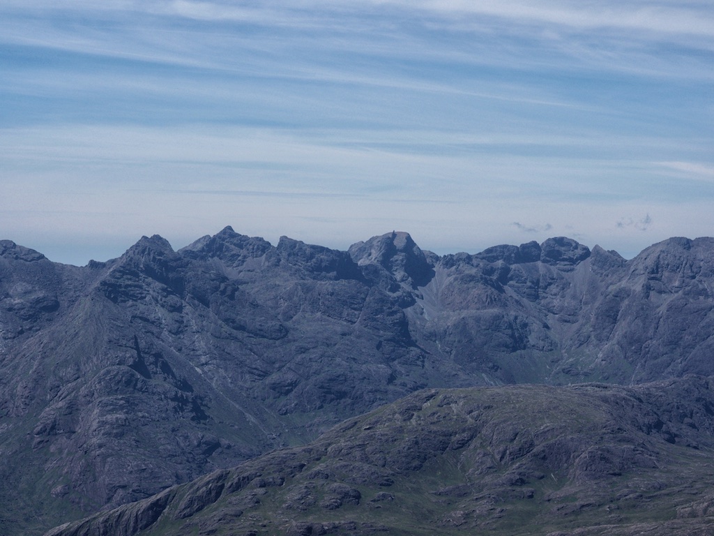
Route No. 100 in Ralph Storers Book 100 Best Routes on Scottish Mountains formed a fitting end to our excursion to the Outer Hebrides in spring 2018. The 2018 trip to Scotland was the first in 25 years during which we climbed no Munro at all having finished our first – and likely last – round of the coveted 282 hills in September 2017 on A’Mhaighdean.

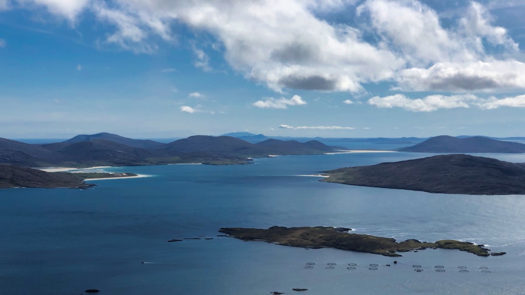
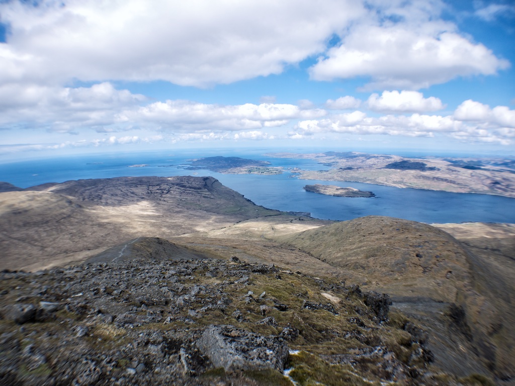
The relatively modest height of these island hills is more than compensated for by their unique setting: The blue Atlantic Ocean in almost every view from the summits, the sea lochs snaking into the heart of North Harris, the white sand and emerald-coloured water of Luskentyre beach, to name but one of them.

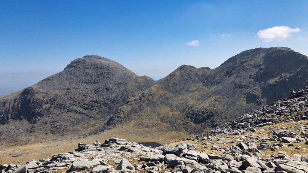
The Clisham circuit of course forms the most challenging and most rewarding high-level trip in Harris. With Tomnaval, Clisham, Mulla bho Deas, Mulla bho Thuath and Mullach an Langa surrounding Loch Vistem and Glen Scaladale this is a ridge walk that need not fear comparisons with many a mainland classic.

We opted for doing the whole circuit in exactly the way Mr Storer describes it. This meant a start at the bridge over the Scaladale River where there was enough space to park our car beside the A859. The hike along the A859 to where the easy path towards Tomnaval branches of to the right took us less than 10 minutes. With the crags of Castail Ard to our left we headed up this hikers highway to the three lochans which appear one after the other close to where the path reaches its highest point. Leaving the path behind we took a line avoiding the crags above Lochan a’Chleit Ard which led us through thick heather up onto the broad shoulder of Tomnaval. Once on the open grassy shoulder it was an easy tramp over successive bands of rock to the summit region of Tomnaval. Before we reached the summit we headed due west to the bealach between this hill and Clisham.

At the bealach we rested for a few minutes before we tackled the … [Read More]

2020-09-23T12:56:10+02:00May 24th, 2018|2018, The Islands|

Ullaval, Oreval, Bidigi, Cleiseval

The week we spent on Harris and Lewis was divided in two parts weather-wise. Coming from Ullapool on the MS Seaforth we had arrived in Stornoway in perfect weather. This had given us the chance to see the beauty of the island(s) on our leisurely drive to Borve (on Harris, in case you ask which Borve). Once we had settled into our great Borvemore cottage there – the Beach House, which as its name indicates is only 300m from the beach – we explored the surroundings. The local graveyard, the grassy stretch of land leading to the wide bay and the sandy beach. Later and as we had intended from the start Alex, Frank and me watched the sun set over the Atlantic Ocean. Very romantic indeed.

Less romantic was the fact that a front from the West then brought us two days of nearly constant downpour. I managed to finish reading my book on the geology of Assynt, Alex and Frank made some short excursions but generally speaking we were stuck in the Beach House.

Then, after this prolonged rainy intermezzo, the weather was benign again and we finally ventured out into the hills of North Harris. Our aim was to see the great overhang of Sron Ulladale and then walk back to the road via the ridge. Via Tarbert we followed the A 859 to where the B887 branches off towards Huinish. We followed this extraordinarily scenic coast road to the point where the private road to Loch Chliostair joins it. A few hundred metres on the private road brought us to a spot where we could park our car close to where the road was blocked off by a barrier.

We continued on foot passing Loch Leosaid and when the road started climbing towards Loch Chliostair we kept following it. From the end of the road we followed the well-engineered footpath along the east shore of the loch. This reservoir nestles very nicely between Tiorga Mhor and Oreval. At its north end a short climb leads to another small loch, … [Read More]

2019-04-28T18:16:58+02:00May 22nd, 2018|2018, The Islands|

Foinaven

Alex, Frank and me had rented a bungalow very close to the ultra-scenic camping ground in Clachtoll perched above the sandy beach by the Atlantic Ocean. We spent two nights there before we took the ferry from Ullapool to Stornoway. The sunset was very beautiful to watch but the whole spot was a wee bit windy and consequently marvelling at the sea, cliffs and sun left us feeling quite cold before we retreated to our living room.

The program for the next day was simple and plain but nonetheless filled Frank and me with anticipation: We finally wanted to climb Foinaven, a hill whose ascent we had postponed for more than a decade because its remote location and “lowly” Corbett status had kept us from taking a day off from our Munro-bagging quest. Nuts. Indeed.

So, the three of us drove up the A838 to Gualin House where we parked our BMW at the hikers’ parking lot. We went back along the road for a few hundred metres past Gualin House and then struck a more or less direct line across the moor towards the north-west ridge of Ceann Garbh. On the way to the foot of the ridge both Alex and me each inadvertently sunk one of our booted legs into one of the many water holes and tiny pools the heathery land held in store for the inattentive hiker. Once on the first grassy than rocky shoulder of Craig na Claise Camaich and the ensuing ridge of Ceann Garbh we made good progress. Some of us went faster, one of us was not so quick. I struggled to keep up with Alex and Frank but finally they disappeared out of sight. Soon I was greeted by the whirring sound of Frank’s quadro-copter drone, indicating the lads were having a break at the summit. Then I joined them not without having inflicted some significant scratches and bruises to myself: When ascending the boulder field below the summit I had lost my footing and fallen sideways and backwards into a cavity between … [Read More]

2019-04-26T08:19:43+02:00May 17th, 2018|2018, The Islands|

Sgurr Dearg – The InPin

In 2007 Frank and I had been acting under the delusion of being able to summit the Inaccessible Pinnacle on our own when we had first visited the Sgurr Dearg summit area. But we soon had realized that climbing the Pinnacle without professional help would be foolhardy to say the least. So on 7 June 2017 we met our friendly guide Ian at the Glen Brittle Memorial Hut (why is it called ‘Memorial’ Hut?). Ian handed us our climbing gear (harness and helmet) and soon we were on our way on the path that leads up towards the Eas Mor and the west ridge of Sgurr Dearg.

After a short test of our stamina and fitness on behalf of Ian, who stormed up the path like a torpedo, we settled into a more leisurely speed suited to our limited energies and lower lung capacities. Anyhow, we made good progress on the excellent path and soon left the grass behind. The lower part of the ridge between Coire na Banachdich and Coire Laggan is quite steep and in the middle of the ascent a chimney of sorts catered for some very mild scrambling in order to avoid an alternative path in the unpleasantly steep scree slope. Soon we topped out on a slightly flatter section of the ridge and continued on the obvious path towards Sgurr Dearg. Ian pointed out the highest source of fresh water in the Cuillins, a little spring where cold water was merrily dripping from one of the rocks. Delicious. The views into the corries below and out towards the sea were stupendous! Only the summits hid in the clouds on this otherwise sunny day.

Then we were getting close to the rocky upper section of Sgurr Dearg’s ante summit(s). Due to the traffic on the ridge and the possibility of someone above us dislodging stones we put on our helmets before we entered into the more scrambly section of the climb towards Sgurr Dearg. Over boulders, along the ridge and along ledges Ian led us through the clouds … [Read More]

2021-09-15T14:55:40+02:00June 9th, 2017|2007, 2017, 2019 - 2010, The Islands|

Sgurr Dubh Mor

June 2017 was a rather wet month in the Northwest Highlands. Frank and I had experienced what it means to be scrambling in the Skye Cuillins in bad weather in 2007 when we climbed five Skye Munros in clag, got drenched to the bones on more than one occasion and turned back a few dozen metres below the summit of Sgurr Dubh Mor because the rocks were wet and slippery on the more exposed parts of the scramble. So this time we patiently waited for a weather forecast predicting acceptable conditions in the Cuillins.

Thursday 8 June 2017 was such a day. At about nine o’clock we parked our car at the end of the public road in Glen Brittle and set off towards Coire a’Ghrunnda. The going on the broad path was easy until we rounded Sron na Ciche and the steep rocky climb into Coire a’Ghrunnda proper started. Once the first steep section was completed at about 400m the lip of the upper corrie girt by large rocks, boulder fields and the outflow of the loch cascading down over a succession of slabs came into view about 250m above our present position. We continued the climb up the steep path on the very left-hand side of the corrie through scree and over boulders in the passing company of three or four other groups of hikers. Some minor scrambling was called for before we reached the Loch Coire a’Ghrunnda at about 700m. This is a real gem of a corrie! We sat close by the shoreline of the loch and marvelled at the scenery trying to name the hills which encircle the loch.

Our aim was Sgurr Dubh Mor which is not visible from the corrie since its slightly lower sibling Sgurr Dubh an da Bheinn and Caisteal a’ Garbh-choire line the main Cuillin ridge and block the view towards the Munro located on a side ridge leading towards the east. From the loch we climbed up towards the Bealach a’ Garbh-choire but aimed too far south so that some … [Read More]

2017-09-19T14:14:56+02:00June 8th, 2017|2017, 2019 - 2010, The Islands|

Bruach na Frithe

After our delightful excursion to Knoydart, Inverie and Meall Buidhe we took the ferry from Mallaig to Armadale and arrived at the Sligachan Hotel around midday. We were definitely not the only people there :-). But soon we left the hustle and bustle of the hotel’s surroundings and the road intersection behind us and climbed the path beside the Allt Dearg Beag.

The going was easy, the path was obvious and the weather was okay with only one stiff shower accompanying our progress. After three kilometres we reached the steep and rocky hillside that blocks easy entrance into Corrie a’Basteir and forms the left side of the Basteir Gorge (orographically, that is). Frank and I followed the more or less obvious path first through scree and then over some ledges in the rocks. Soon the path passed above the Basteir Gorge and took us into beautiful Corrie a’Basteir. We paused for ten minutes in the corrie and took in the views of Pinnacle Ridge, Am Basteir and the Basteir Tooth. A great place to be in the sunshine which we were lucky enough to have on this Saturday afternoon.

You can never get enough of such views but we finally tore ourselves away from them and embarked on the steep climb towards Bealach a’Basteir which we reached just as heavy rain set in. Rats! I was a little slower than Frank so that when I reached the Bad Step in the ridge of Am Basteir Frank was already coming back and I decided that I would not continue to the summit in view of the very slippery surface of the basalt rocks.

Instead we returned to Bealach a’Basteir, contoured around the foot of Am Basteir, gained Bealach na Lice and continued to Bruach na Frithe which Frank climbed in thick clouds while I waited for him on the ridge. With the second Munro of this walk bagged by Frank we returned to Bealach na Lice and followed the well-cairned and easy path leading down into Fionn Choire and towards the Allt Dearg Mor. … [Read More]

2017-09-19T14:14:56+02:00June 3rd, 2017|2000, 2017, 2019 - 2010, The Islands|

Am Basteir

After our delightful excursion to Knoydart, Inverie and Meall Buidhe we took the ferry from Mallaig to Armadale and arrived at the Sligachan Hotel around midday. We were definitely not the only people there :-). But soon we left the hustle and bustle of the hotel’s surroundings and the road intersection behind us and climbed the path beside the Allt Dearg Beag.

The going was easy, the path was obvious and the weather was okay with only one stiff shower accompanying our progress. After three kilometres we reached the steep and rocky hillside that blocks easy entrance into Corrie a’Basteir and forms the left side of the Basteir Gorge (orographically, that is). Frank and I followed the more or less obvious path first through scree and then over some ledges in the rocks. Soon the path passed above the Basteir Gorge and took us into beautiful Corrie a’Basteir. We paused for ten minutes in the corrie and took in the views of Pinnacle Ridge, Am Basteir and the Basteir Tooth. A great place to be in the sunshine which we were lucky enough to have on this Saturday afternoon.

You can never get enough of such views but we finally tore ourselves away from them and embarked on the steep climb towards Bealach a’Basteir which we reached just as heavy rain set in. Rats! I was a little slower than Frank so that when I reached the Bad Step in the ridge of Am Basteir Frank was already coming back and I decided that I would not continue to the summit in view of the very slippery surface of the basalt rocks.

Instead we returned to Bealach a’Basteir, contoured around the foot of Am Basteir, gained Bealach na Lice and continued to Bruach na Frithe which Frank climbed in thick clouds while I waited for him on the ridge. With the second Munro of this walk bagged by Frank we returned to Bealach na Lice and followed the well-cairned and easy path leading down into Fionn Choire and towards the Allt Dearg Mor. … [Read More]

2019-01-03T17:12:15+01:00June 3rd, 2017|2000, 2017, 2019 - 2010, The Islands|

Bla Bheinn (Blaven)

The best day, at least weather-wise, was also the last day of the 2016 holiday in Scotland. After five days of fog, two days of wind and rain and one further beautiful day this hike was the saving grace of an otherwise rather viewless bagging season.

Knowing the weather would be very good we had decided to climb Blaven via its south ridge since this would afford us marvellous views of the Black Cuillins on the way up. Like quite a few other walkers we started the hike from the parking south of Kilmarie where a Landrover track crosses the Strathaird peninsula. The track undulates a bit but then rises to its highest point (Am Mam) and drops again on its way towards Camasunary. Shortly before the next sharp bend in the track a path leads off towards the foot of the south ridge of Blaven. In due time this path crosses a small burn. A few metres past the burn the path leading up the steep grass slopes of the mountain’s south ridge branches off at an altitude of approximately 100m.

We climbed this very steep slope on the good path which further up outflanks the first bands of rock to the right before it leads up a steep gully filled with scree. Then at about 380m the path suddenly reaches the crest of the ridge and the complete Black Cuillin ridge springs into view. I took a break there and enjoyed the views which really were to die for.

From this spot onwards there is not much grass left underfoot as slabs of rock, small boulders and scree form the ground your boots tread on. The way forward was marked by cairns though and route-finding was not a problem. Over several steps in the ridge – which gave opportunity for some mild scrambling – the path follows the crest of the ridge or uses easier terrain on the east side of the hill. Further up the mountain it was not so easy to discern a path or rather the right path … [Read More]

2017-09-19T14:14:57+02:00June 18th, 2016|2016, 2019 - 2010, The Islands|

Ben More

The last day in Alba in May 2012 saw us climbing the only Island Munro outside Skye: Ben More on Mull.

We definitely did not want to save this hill as the last one in our first round of Munros. First, it simply did not feel right to us to do it like so many others. Second, we have neither unfit members of family nor unfit friends to accompany us to the summit of the last one so we need not pick an easy mountain for the final tour. Third, we wanted to see Mull this beautiful island in 2012 and not in 2016.

With these principal deliberations accomplished well before we left for Scotland in 2012 we had sailed to from Oban to Craignure the evening before, had spent a nice Friday evening and a relaxing night at the Craignure Inn and then had set out on the road trip to Loch na Keal. At Dhiseag we parked our car on the grass facing the sea. This being a Saturday morning we were in the company of MANY other hillwalkers: Children, men, women, grandads, grandmas, families.

We chose the easiest approach, the north-west ridge. Beside the Abhainn Dhiseig we climbed first on its right bank than beside the left bank. The going was easy on grass of only moderate steepness. Higher up the slope got steeper and considerably more rocky. It got colder, too. The wind was strong. The last 150-200 metres below the summit take the form of a skyline highway: A very broad and gritty path up the ridge. Very comfortable and good to keep up a steady walking rhythm. The summit ridge is flat and a few hundred metres long. There is a wide round stone wall on the summit which offers some protection from the wind. The views from the summit are spacious and very beautiful with all the smaller islands and other summits of Mull being in full view! Having bagged the summit and looking forward to a nice car tour of Mull we decided to head … [Read More]

2021-10-29T07:50:08+02:00May 5th, 2012|2012, 2019 - 2010, The Islands|

Sgurr Mhic Choinnich

On a dry day in May 2007 the two valiant hill-walkers set out to climb the Inaccessible Pinnacle and Sgurr Mhic Choinnich in one outing. Alas, it was not to be (in its entirety, d’you see?). But let’s start at the beginning. From Glen Brittle House we climbed the path leading to the Eas Mor and once past the waterfall we branched right in the direction of Loch an Fhir-bhallaich.

Half-way to the loch another path branches off to the left and approaches the steep west ridge of Sgurr Dearg. Gaining height quite quickly the view soon opened up and Corrie na Bachachdich impressed with its great scenery. At about 750 m the clouds finally won and we climbed up the final steep, slabby and stoney steps of the ridge before reaching the summit of Sgurr Dearg. There the Inaccessible Pinnacle finally became visible through the clouds. Nice piece of rock. We slithered to the basis of the pinnacle and checked the start of the climb. Other groups of climbers made their way up the Inaccessible Pinnacle while we watched. Finally we started our climb – without using the rope.

We soon realised that the climb was not really difficult but quite exposed. And since we had not really expected the need for using the rope for other purposes than abseiling we decided to be wise and go back and to leave the In Pinn for another day. I explored the summit of An Stac before Frank and I contoured around its basis on the scree-strewn slanting path leading to the broadish (by Skye standards at least) Beallach Corrie Laggan. About here the visibility improved dramatically and the views were stupendous later. From the beallach we followed the trace of a path that leads up to Sgurr Mhic Choinnich. This part of our hike was real fun with easy scrambling and exposed sections on the knife-edge ridge. All too soon the summit was gained and we paused there sitting on this marvellous view point perched high above Corrie Laggan.

Incidently … [Read More]

2017-09-19T14:17:50+02:00May 25th, 2007|2007, 2009 - 2000, The Islands|
Go to Top