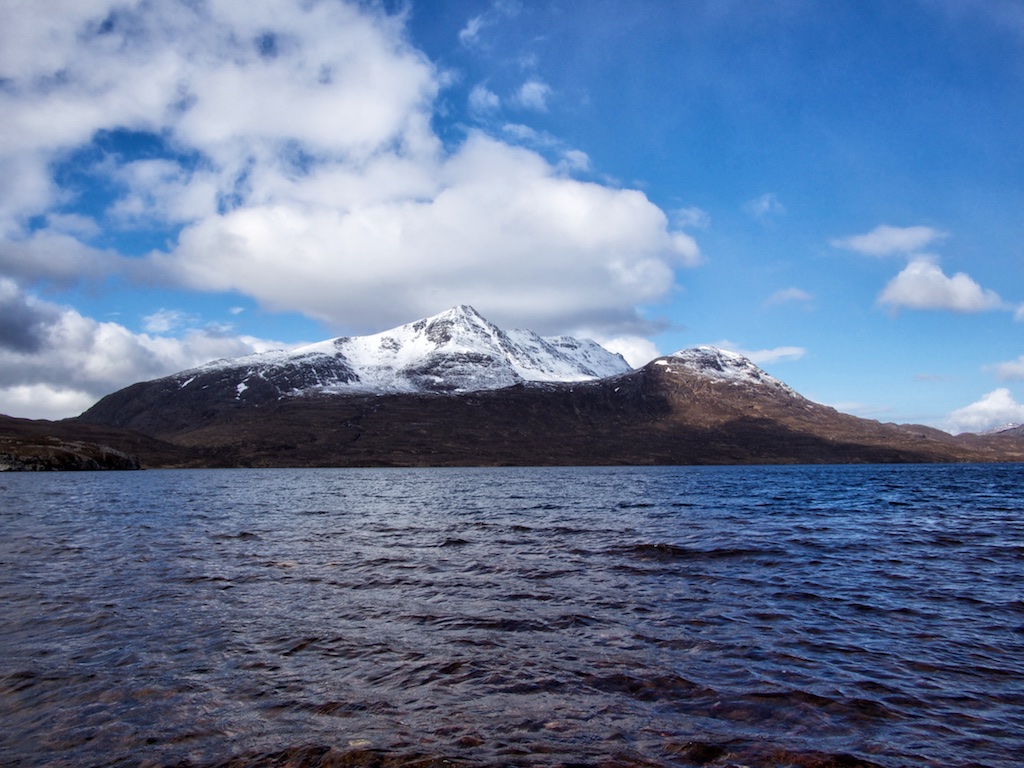
Maol Chean-dearg

The last hill tour of the 2015 “campaign” was the bare red headed hill of the Ben Damph / Coulin Forrest. Frank and I parked the Volvo at the lochside layby in Annat. While getting our things together we were joined by a mountain biker who also wanted to head for Maol Chean-dearg. We chatted a bit and after some “see you later” we set off behind him.

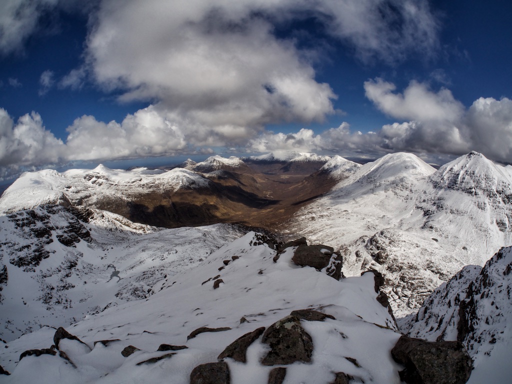
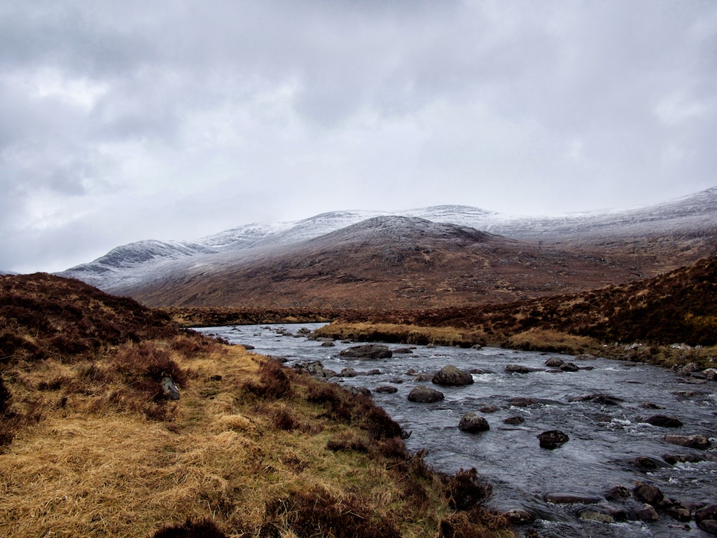
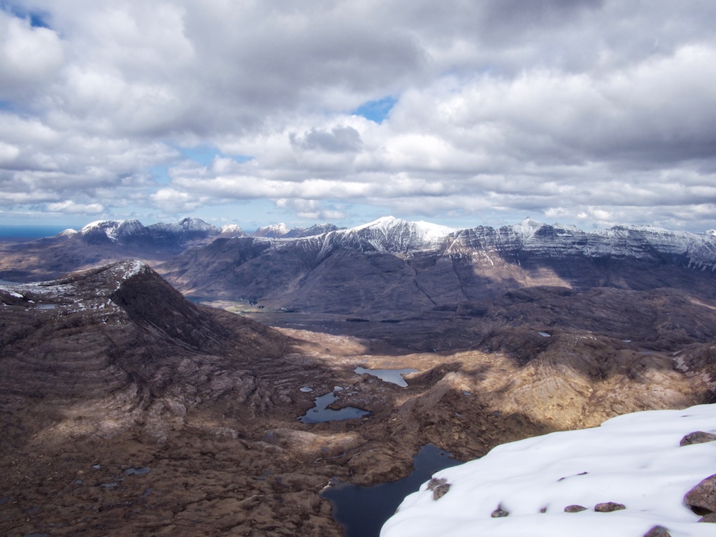
I (Cord) had already climbed Maol Chean-dearg from Annat in 2000 so the good path on gravel and over slabby terrain was kind of familiar. It climbs to an altitude of about 300m and then levels off when it reaches the flat terrain characterized by slabs, sand and two or three small lochans lying between Beinn na h-Eaglaise and Meall Dearg. Having passed Lochan Domhain we soon came to the banks of Loch an Eion. From there the north face of Maol Chean-dearg was quite an impressive view both ahead and also as reflected in the loch.

Again as I had done in 2000 we took the right-hand fork and followed the path around the west and later south flank of the hill towards the beallach between Maol Chean-dearg and An Ruadh Stac. This path rises steadily and more or less gently towards Loch Coire an Ruadh Stac and further on to a small round lochan with whitish quartzite walls that nestles nicely between the two hills. Here we again met “our” mountain biker who had embarked on the trip back to the car.

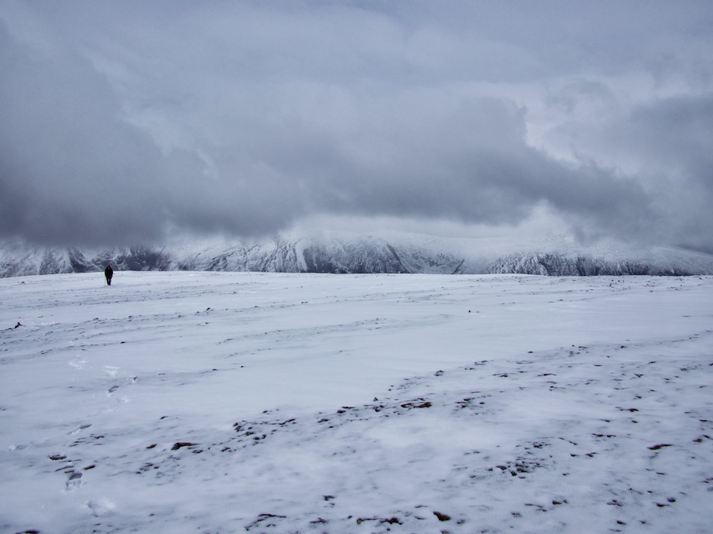
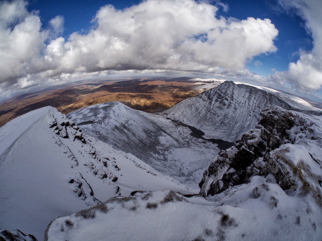
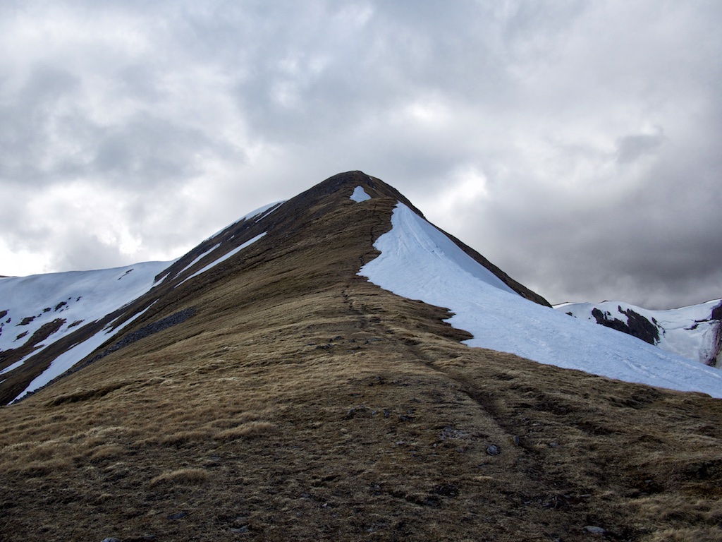
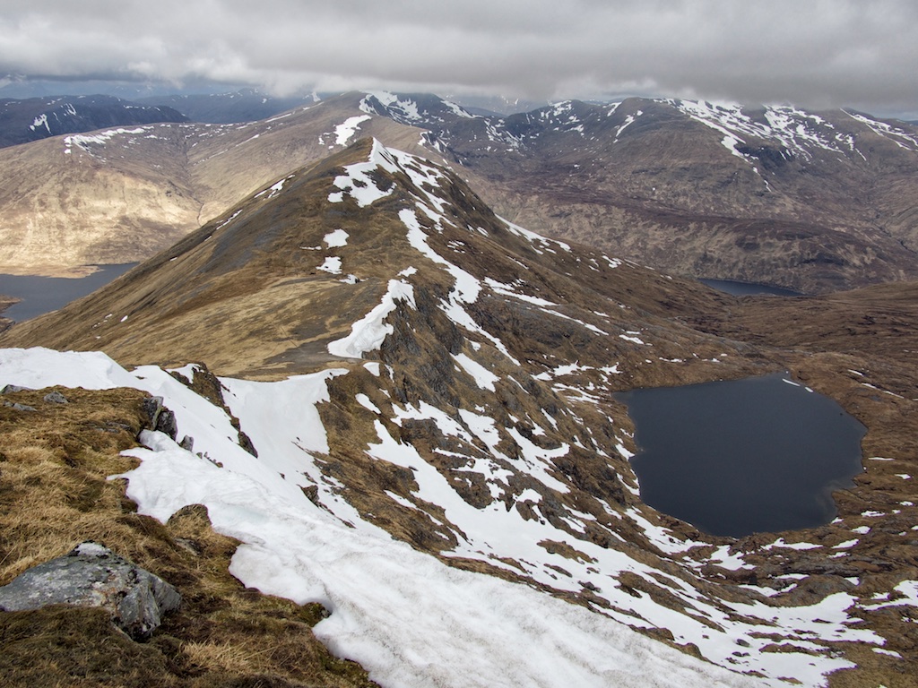
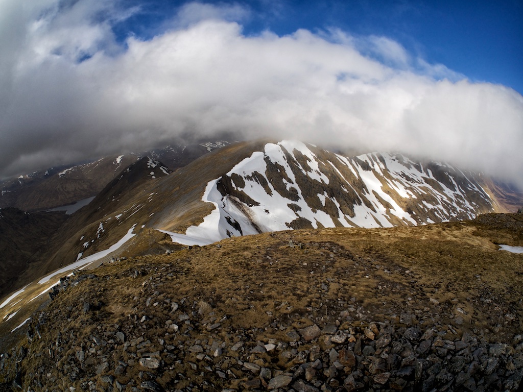
At the 590m beallach we had our second break of the walk and ate sandwiches basking in the sunshine. We left our rucksacks at the beallach and started the stiff climb up the steep 150m of the ridge consisting of quartzite and quartzite scree. From my memory I knew that a more level section would follow that also has a lot of quartzite slabs standing upright due to folding. Here snow covered the ground in some spots.

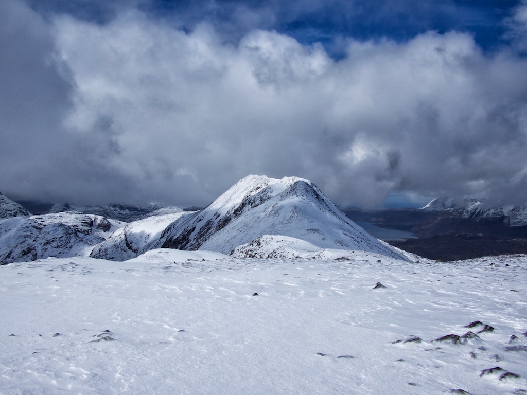
Then the terrain became grassy underfoot for a few hundred metres before the final steep … [Read More]

2019-09-11T03:58:51+02:00May 1st, 2015|2000, 2015, 2019 - 2010, Strath Orchy to Loch Leven|

Beinn Tarsuinn

Finally. The Wilderness.

Splendid morning sunshine had greeted us when we left our house on the Coulin Estate to drive up to the road in Glen Torridon and further on to Kinlochewe and Incheril. At the parking in Incheril, we unloaded the bicycles, checked our equipment shouldered our rucksacks and set off in the direction of the heights of Kinlochewe. Cycling on this very flat and easy dirt road beside the Abhainn Bruachaig was a nice start to the long day we intended to spend in the Great Wilderness bagging Beinn Tarsuinn, Mullach Choire Mhic Fhearchair and Sgurr Ban. The Heights of Kinlochewe came into sight very soon. We left out bicycles at the spot where a rough Landrover track branches off to the left and steadily climbs the hillside. Vehicular access was barred anyway by a high gate.

Thus we continued the tour on foot. The hiking was pleasant and we gained height quickly enough. We walked high above the Abhainn Gleann na Muice and then switched over to the other side of the glen as the track crossed the Abhainn. The continuation saw us climbing up the in places steepish Landrover track to a point where the glen gives way to the flat moorland at between Gleann na Muice and Loachan Fhada. The weather being good this was a great hike since ahead the silhouettes of Slioch, A’Mhaighdean and Beinn Tarsuinn beckoned. The path is extremely well-maintained here there was no threat of wet feet or stumbling over rocks. The path passed a ruined building and after maybe six kilometres since we had crossed the Abhainn Gleann na Muice we finally reached fabled Lochan Fhada which indeed lies in a lonely, remote and forgotten stretch of Highland wilderness. An enchanting spot where the water of the Lochan lapped sandy “beaches”.

We spent a few minutes at the Lochan and then turned our attention to finding the path mentioned in the books which should get us started on our way to the Munros. We finally made out a faint path and started … [Read More]

2017-09-19T14:14:59+02:00April 30th, 2015|2015, 2019 - 2010, Loch Marree to Loch Broom|

Maoile Lunndaidh

Craig in Glen Carron. Today this place was to be the starting point for another hike high above the bank of the Allt a’Chonais and later in Gleann Fhiodhaig. We had started walks here in 2008 (Sgurr Choinnch and Sgurr a’Chaorachain) and in 2009 (Sgurr nan Ceannaichean before the SMC stole this Munro from our list).

We used bicycles for the approach to Maoile Lunndaidh and rode/pushed them up the Landrover track for almost 10 km until we reached the small fir plantation in Gleann Fhiodhaig which can be found 1 km before the track reaches Glenuaig Lodge. There we left the bicycles and started a gently rising traverse across the grassy hillside towards the north ridge of Maoile Lunndaidh. On the way we crossed the An Crom allt and headed towards the outflow of the lochans nestled in the narrow corrie (Fuar tholl Mor) between the Munro of the day and the north ridge of Carn nam Fiaclan. It was a wet and overcast day. Visibility was moderate at first.

At an altitude of about 500 m the grass began to be sprinkled with snow and as soon as we reached the level floor of the quite impressive Fuar tholl Mor snow covered the ground completely. From the corrie we climbed up a rocky spur covered in heather making good use of a faint path. Then all that was left was to climb the very broad and open north ridge of Maoile Lunndaidh, which was quite steep initially and progress over (or through) the knee-deep snow was a real effort. We zigzagged our way up the ridge making good use of grass and stones which barely peeked out from the deep snow.

Then the ridge levelled off and the visibility became much better. We even enjoyed a spot of sunshine when we arrived at the summit cairn. Due to the round nature of the summit this is a moderately good viewing spot only but it sufficed to walk a few dozen metres towards the narrow stretch linking Maoile Lunndaidh and … [Read More]

2017-09-19T14:14:59+02:00April 29th, 2015|2015, 2019 - 2010, Glen Cannich to Glen Carron|

Beinn Liath Mhor

Due to bad motivation and even worth weather when i first tried to tackle it in 2000 Beinn Liath Mhor was still on my ticking list. Call it fate or just coincidence but the choosen location of the 2015 session made me use a very seldom choosen approach – in terms of locations and transportation – from Coulin. To save me some steps Cord offered to drive me from our cottage using the landrover track with our Fiat 500 upgrade called V70. After a little consideration where we should end our approach trip, he dropped me off a little bit too early, the V70 would have easily made the 1.5 miles to the hut, but never mind. The hut is in a very good state except the paint choosen if you take the notes in the hut seriously.

The walk along Easan Dorcha is exceptional beautiful and does in my opinion not lack comparison to the walk up Glen Derry. After reaching Drochaird Coire Lair – pittily in worsening weather – i started the very, very steep and narrow ascent to the ridge. I have not seen that many steep and narrow ascents, here you can trust me. The bad weather and the steepness accompinied me to Point 876. There only the steepness left me. It had snowed very heavy end of this April 2015 and i walked in newly snow up to my knees ignoring happily all the covered stone pits which i hit constantly more often than needed.

And up on the ridge two old friends accompanied me: “Gustly Winds” and “Hardly No Views”. Luckily the ridge is this defined that my eldest friend “Navigational Problems” should join me only later that day. After Point 876 i enyjoyed the downhill session which ended too soon with the reascent to Point 887. I was lucky that the elements enabled me to take some very dramatic pictures – where i met a long time forgotten fourth friend named “Loose My Glove”. There it went. Black Shadow. But since that remarkable day … [Read More]

2018-09-01T15:17:16+02:00April 28th, 2015|2000, 2015, 2019 - 2010, Coulin and Torridon|

Slioch

Residing in our marvellous house on the Coulin Estate meant that reaching the start of the hike involved only a fifteen minute drive to Kinlochewe. The day started out with good weather. At the parking in Incherill we changed into boots and packed our rucksacks in sunshine and cold air. Then everything was where it should be and we embarked on this long-anticipated hike along the north shore of Loch Maree towards Gleann Bianasdail. As can be read in many a description this six or seven kilometre walk first along the banks of the Kinlochewe River and then a little further on along the shore of the loch is very pleasant, a little undulating and much of the stretch can be covered walking on grass. It would have been a perfect day had we not encountered a succession of rather smelly carcasses of decomposing deer which littered the shoreline every now and then. Winter had been long and hard! All in all we saw eight or ten of them; and smelled one or two more. Yuck!

After 70 or 80 minutes we crossed the bridge over the Abhainn an Fhasaigh and immediately turned due north along the somewhat rough path that climbs grassy slopes interspersed with inclined and horizontal slabs of sandstone. The slope gets steeper the higher up you get. Sgurr Dubh boldly rises ahead to the left and we followed the path heading for the beallach between this hill and Meall Each. At about 500m the first specs of snow appeared and close to where the path levels off as it reaches the flat expanse of Coire Tuill Bhain it turned into a quagmire of slush and muck.

Checking out the two possible ways to the summit(s) from the corrie we soon decided that in these conditions of late winter and us carrying no ropes the more sensible approach seemed to be via Sgurr an Tuill Bhain and its south-east ridge which throws one arm down towards the corrie floor. We crossed the corrie where deep snow covered the heather … [Read More]

2017-09-19T14:14:59+02:00April 27th, 2015|2015, 2019 - 2010, Loch Marree to Loch Broom|

Am Faochagach

The third day of our hillwalking holiday in Alba was to be a day of transiting from Ullapool to Torridon. So the Munro bagging goal of the day was to climb Am Faochagach, a hill which is not very far from the A 835 which should be doable in five to six hours. We parked at the small parking beside the bridge over the Abhainn an Torrain Duibh. The day was overcast and sported the occasional rain shower at glen level. So it was a constant question of wearing your rain gear or not. From the road we followed the very wet path that leads to the Abhainn a’ Gharbhrain, the short river connecting the Loch of the same name and Loch Glascarnoch. With the last weeks of a very wintry spring still leaving their mark and quite a bit of melting going on nonetheless it was likely that this river which is notorious for being difficult to cross would call for some wading. And that’s what we soon found out to be true. When we reached the right-hand bank of the Abhainn the boots soon went off, the trousers were rolled up and we waded the river. That was ok even though the water was very cold.

Once over the river we climbed up on the moraine that leads in a north-easterly direction towards the hill of the day. Where it ended we picked up a path beside the Allt na h-Uidhe and steadily climbed towards the whaleback of the hill. We reached a wide beallach on the ridge at about 700m and turned due north. Here the hill was covered in maybe 10 cm of fresh snow. We climbed another 120m until we found ourselves on a plateau-ish ridge which we followed north. Visibility was only moderate but after another kilometre we reached the start of the final steepening that signalled the last 130m leading towards the summit dome of Am Faochagach. These consisted of banks of deep snow alternating with grassy and stony sections (solifluction forming the slope). … [Read More]

2017-09-19T14:14:59+02:00April 26th, 2015|2015, 2019 - 2010, Loch Broom to Easter Ross|

Seana Bhraigh

2015 was the year set aside for climbing all of the Munros still left in the north of Scotland. The northernmost of these was Seanna Braigh. Since we had stayed in Ullapool for the night the logical approach to the hill was from Inverlael; even though we had been there so often before and the first three kilometres of the hike would be more than well-known to us. Alas, what can you do?

So we started from the parking beside the A835 walking up the forest road to the ruin in Glensquaib in acceptable weather. Soon some layers of protective clothing needed to be shed. After maybe 35 minutes we reached the Glensquaib ruin and embarked on the steep and stony track that leads up to Druim na Saobhaidhe. Once more level terrain was reached the track was completely covered by snow which resulted in us heading too far to the south-east. Once we had realized the error we turned in a more northerly direction to reach the ford over the Allt Gleann a’Mhadaidh.

There we crossed the stream. The ensuing track was well discernible even under snow and we climbed it for another three kilometres until we reached the succession of lochans in Coire an Lochain Sgreirich. At the head of the corrie more snow completely obliterated the path and we were left to our own devices. After maybe fifteen minutes of treading deep snow we reached the spot where a descent down a steep gully between two tops gives access to the rocky knolls below leading to Cadha Dearg. At the head of Cadha Dearg, which has the appearance of a rocky, sharp and deep glen from there, we paused to marvel at the views. A magnificent place and we had it all to ourselves – the last other hikers we met that day having retraced their steps towards Inverlael long before.

From Cadha Dearg onwards we enjoyed occasional rays of sunshine during an otherwise cloudy day. From the cleft we headed up steepish slopes covered in fresh snow towards point … [Read More]

2020-09-23T16:21:21+02:00April 25th, 2015|2015, 2019 - 2010, Loch Broom to Easter Ross|

Mam Sodhail

2015 was to be the year, when we wanted clear the far north of red flags (unbagged Munros on the maps of www.bgmb.de). With a few left to tick in Torridon, Fisherfield and the Ullapool hills we had a long drive north ahead of us in order to get where we wanted to: Our hunting lodge by Loch Coulin and the B&B in Ullapool to start with. But before the far north could be tackled we had unfinished business a little further south in Glen Affric which needed our attention. For me that meant Beinn Fhionnlaidh and for Frank it meant the whole group of Carn Eighe, Mam Sodhail and Beinn Fhionnlaidh. So our trip up from EDI took us to the Tomich Hotel, ideally suited as a starting point for this grand tour in Affric. We arrived early enough to sit outside, to bask in some of the warm sunshine and to have nice pint of lager. After a good meal, an early night and a full breakfast, we were at the start of the hike before ten o’clock the next morning: The parking where the Abhainn Gleann nam Fiadh flows into Loch Bheinn a’Mheadhoin.

Since we had already climbed Toll Creagach and Tom a’Choinich from there years earlier the Landrover track was well known to us. We quickly made progress on this good track and reached the spot where the path by the Allt Toll Easa branches off. We continued straight ahead on the path beside the Abhainn Gleann nam Fiadh further up into the wide open corrie/moor. After two more kilometres we headed up steepish terrain on grass and snow fields leading towards the Garbh Beallach. From there we continued up narrow sections of the ridge (the stalkers’ stairway) towards Sron Garbh and Stob aí Choire Dhomhain. The ridge between these two is studded with a few rock towers which meant some pleasant scrambling or bypassing on the path provided for either of us. Soon the summit of Carn Eighe came into view. Once there we had a … [Read More]

2017-09-19T14:14:59+02:00April 24th, 2015|1999, 2015, 2019 - 2010, Glen Affric and Kintail|

Beinn Fhionnlaidh

2015 was to be the year, when we wanted clear the far north of red flags (unbagged Munros on the maps of www.bgmb.de). With a few left to tick in Torridon, Fisherfield and the Ullapool hills we had a long drive north ahead of us in order to get where we wanted to: Our hunting lodge by Loch Coulin and the B&B in Ullapool to start with. But before the far north could be tackled we had unfinished business a little further south in Glen Affric which needed our attention. For me that meant Beinn Fhionnlaidh and for Frank it meant the whole group of Carn Eighe, Mam Sodhail and Beinn Fhionnlaidh. So our trip up from EDI took us to the Tomich Hotel, ideally suited as a starting point for this grand tour in Affric. We arrived early enough to sit outside, to bask in some of the warm sunshine and to have nice pint of lager. After a good meal, an early night and a full breakfast, we were at the start of the hike before ten o’clock the next morning: The parking where the Abhainn Gleann nam Fiadh flows into Loch Bheinn a’Mheadhoin.

Since we had already climbed Toll Creagach and Tom a’Choinich from there years earlier the Landrover track was well known to us. We quickly made progress on this good track and reached the spot where the path by the Allt Toll Easa branches off. We continued straight ahead on the path beside the Abhainn Gleann nam Fiadh further up into the wide open corrie/moor. After two more kilometres we headed up steepish terrain on grass and snow fields leading towards the Garbh Beallach. From there we continued up narrow sections of the ridge (the stalkers’ stairway) towards Sron Garbh and Stob aí Choire Dhomhain. The ridge between these two is studded with a few rock towers which meant some pleasant scrambling or bypassing on the path provided for either of us. Soon the summit of Carn Eighe came into view. Once there we had a … [Read More]

2017-09-19T14:14:59+02:00April 24th, 2015|2015, 2019 - 2010, Glen Affric and Kintail|

Carn Eighe

2015 was to be the year, when we wanted clear the far north of red flags (unbagged Munros on the maps of www.bgmb.de). With a few left to tick in Torridon, Fisherfield and the Ullapool hills we had a long drive north ahead of us in order to get where we wanted to: Our hunting lodge by Loch Coulin and the B&B in Ullapool to start with. But before the far north could be tackled we had unfinished business a little further south in Glen Affric which needed our attention. For me that meant Beinn Fhionnlaidh and for Frank it meant the whole group of Carn Eighe, Mam Sodhail and Beinn Fhionnlaidh. So our trip up from EDI took us to the Tomich Hotel, ideally suited as a starting point for this grand tour in Affric. We arrived early enough to sit outside, to bask in some of the warm sunshine and to have nice pint of lager. After a good meal, an early night and a full breakfast, we were at the start of the hike before ten o’clock the next morning: The parking where the Abhainn Gleann nam Fiadh flows into Loch Bheinn a’Mheadhoin.

Since we had already climbed Toll Creagach and Tom a’Choinich from there years earlier the Landrover track was well known to us. We quickly made progress on this good track and reached the spot where the path by the Allt Toll Easa branches off. We continued straight ahead on the path beside the Abhainn Gleann nam Fiadh further up into the wide open corrie/moor. After two more kilometres we headed up steepish terrain on grass and snow fields leading towards the Garbh Beallach. From there we continued up narrow sections of the ridge (the stalkers’ stairway) towards Sron Garbh and Stob aí Choire Dhomhain. The ridge between these two is studded with a few rock towers which meant some pleasant scrambling or bypassing on the path provided for either of us. Soon the summit of Carn Eighe came into view. Once there we had a … [Read More]

2017-09-19T14:15:00+02:00April 24th, 2015|1999, 2015, 2019 - 2010, Glen Affric and Kintail|
Go to Top